
Geographic Region: GREECE
Feature: EVVOIA ISL/GULF,ATHENS
|
Geographic Region: GREECE Feature: EVVOIA ISL/GULF,ATHENS |
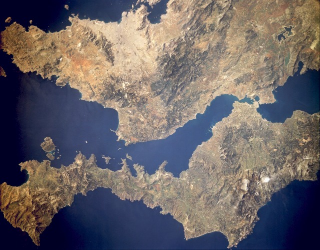 |
| STS036-151-95 Euboea Island and Athens, Greece March 1990 The historic city of Athens and nearby Euboea Island, also known as Evvoia Island, are visible in this near-vertical photograph. Athens, the largest city in Greece (brownish-tan area), is located on the Plain of Attica. At times the city has some of Europe's most polluted air. The city is the administrative, economic, transportation, and cultural center of Greece. Manufactures include oil refinery products; silk, wool, and cotton textiles; machine tools; steel mills; shipyards; food and beverage products; chemicals; pottery; printed materials; and carpets. Tourism is also a major industry. Athens supports a world-famous national library and numerous schools of archeology. Located east of Athens across the Petalion Gulf is Euboea Island, which is separated from mainland Greece by the Evripos Strait. The island is 90 miles (145 kilometers) long, 4 to 30 miles (6 to 48 kilometers) wide, and covers 1467 square miles (3800 square kilometers). On the island sheep, goats, and cattle are raised in the fertile valleys; olives, grapes, and wheat are grown; magnesite and lignite are mined; and marble is quarried. |
| Images: | All Available Images Low-Resolution 121k |
|
| Mission: | STS036 |
|
| Roll - Frame: | 151 - 95 |
|
| Geographical Name: | GREECE |
|
| Features: | EVVOIA ISL/GULF,ATHENS |
|
| Center Lat x Lon: | 38.0N x 24.0E |
|
| Film Exposure: | N | N=Normal exposure, U=Under exposed, O=Over exposed, F=out of Focus |
| Percentage of Cloud Cover-CLDP: | 0 |
|
| Camera:: | LH |
|
| Camera Tilt: | NV | LO=Low Oblique, HO=High Oblique, NV=Near Vertical |
| Camera Focal Length: | 250 |
|
| Nadir to Photo Center Direction: | The direction from the nadir to the center point, N=North, S=South, E=East, W=West |
|
| Stereo?: | Y | Y=Yes there is an adjacent picture of the same area, N=No there isn't |
| Orbit Number: | |
|
| Date: | 1990____ | YYYYMMDD |
| Time: | GMT HHMMSS |
|
| Nadir Lat: | N |
Latitude of suborbital point of spacecraft |
| Nadir Lon: | E |
Longitude of suborbital point of spacecraft |
| Sun Azimuth: | Clockwise angle in degrees from north to the sun measured at the nadir point |
|
| Space Craft Altitude: | nautical miles |
|
| Sun Elevation: | Angle in degrees between the horizon and the sun, measured at the nadir point |
|
| Land Views: | COAST, ISLAND, MOUNTAIN, HILL |
|
| Water Views: | GULF, STRAIT, LAKE, SEA |
|
| Atmosphere Views: | |
|
| Man Made Views: | URBAN AREA, AIRPORT |
|
| City Views: | ATHENS |
|
Photo is not associated with any sequences | ||
| NASA Home Page |
JSC Home Page |
JSC Digital Image Collection |
Earth Science & Remote Sensing |
|
This service is provided by the International Space Station program and the JSC Earth Science & Remote Sensing Unit, ARES Division, Exploration Integration Science Directorate.

|