Geographic Region: LIBYA
Feature: AWBARI,PIVOT IRRIG, SS
|
Geographic Region: LIBYA Feature: AWBARI,PIVOT IRRIG, SS |
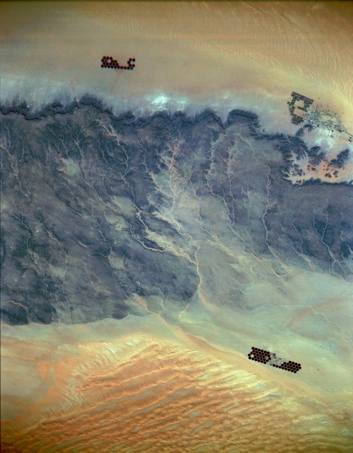 |
| STS036-151-16 Southwest Libya March 1990 The desert scene in this photograph is located just west of one of the few strategic north-south trade routes through southwest Libya. The extensive oasis of Ubari (northeast part of the photograph) is located just north of the darker, eroded, rocky desert. The desert extends in a general northeast-southwest direction for approximately 45 miles (75 kilometers), from the discernible northern escarpment to the northern edge of the sandy Marzuq Desert. A well-entrenched drainage pattern indicates flows toward the south and southeast. The darker rock outcrops are slightly tilted sedimentary rocks sandwiched between the sandy Ubari and Marzuq Deserts. The vivid, dark green, circular features are center-pivot irrigated fields---usually 0.5 mile (0.8 kilometer) in diameter---where sufficient well water is available to practice farming. |
| Images: | All Available Images Low-Resolution 99k |
|
| Mission: | STS036 |
|
| Roll - Frame: | 151 - 16 |
|
| Geographical Name: | LIBYA |
|
| Features: | AWBARI,PIVOT IRRIG, SS |
|
| Center Lat x Lon: | 26.0N x 12.5E |
|
| Film Exposure: | N | N=Normal exposure, U=Under exposed, O=Over exposed, F=out of Focus |
| Percentage of Cloud Cover-CLDP: | 0 |
|
| Camera:: | LH |
|
| Camera Tilt: | NV | LO=Low Oblique, HO=High Oblique, NV=Near Vertical |
| Camera Focal Length: | 250 |
|
| Nadir to Photo Center Direction: | The direction from the nadir to the center point, N=North, S=South, E=East, W=West |
|
| Stereo?: | Y | Y=Yes there is an adjacent picture of the same area, N=No there isn't |
| Orbit Number: | |
|
| Date: | 1990____ | YYYYMMDD |
| Time: | GMT HHMMSS |
|
| Nadir Lat: | N |
Latitude of suborbital point of spacecraft |
| Nadir Lon: | E |
Longitude of suborbital point of spacecraft |
| Sun Azimuth: | Clockwise angle in degrees from north to the sun measured at the nadir point |
|
| Space Craft Altitude: | nautical miles |
|
| Sun Elevation: | Angle in degrees between the horizon and the sun, measured at the nadir point |
|
| Land Views: | DESERT, DUNE |
|
| Water Views: | |
|
| Atmosphere Views: | |
|
| Man Made Views: | PIVOT IRRIGATION, AGRICULTURE |
|
| City Views: | |
|
Photo is not associated with any sequences | ||
| NASA Home Page |
JSC Home Page |
JSC Digital Image Collection |
Earth Science & Remote Sensing |
|
This service is provided by the International Space Station program and the JSC Earth Science & Remote Sensing Unit, ARES Division, Exploration Integration Science Directorate.

|