
Geographic Region: EGYPT
Feature: ALEXANDRIA, SEDIMENT
|
Geographic Region: EGYPT Feature: ALEXANDRIA, SEDIMENT |
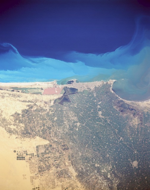 |
| STS036-151-100 Alexandria, Egypt March 1990 The seaport city of Alexandria, with a population of more than 3.5 million, is built primarily on a sandy strip of land between the Mediterranean Sea and Lake Mareotis. An industrial and commercial city, Alexandria anchors the western extent of the large Nile River Delta. Although most of the city infrastructure is not visible, some of the large modern harbor facilities, including a breakwater structure, are discernible in the small bay. The unusual tan water body southwest of the port facilities is possibly a holding pond for industrial effluents. A narrow band of darker substance in the water current appears to be flowing toward the east, and farther offshore, an interesting light blue turbidity indicates water color boundaries along this part of the Mediterranean Sea. A series of canals and roadways appears within the darker green of the fertile, intensively cultivated and irrigated, agricultural Nile River Delta. Circular field patterns southwest of the city indicate that center-pivot irrigation is being used in addition to irrigation from ditches and canals. The smaller, highly reflective areas scattered among the irrigated farmland are villages and cities. |
| Images: | All Available Images Low-Resolution 92k |
|
| Mission: | STS036 |
|
| Roll - Frame: | 151 - 100 |
|
| Geographical Name: | EGYPT |
|
| Features: | ALEXANDRIA, SEDIMENT |
|
| Center Lat x Lon: | 31.0N x 30.0E |
|
| Film Exposure: | N | N=Normal exposure, U=Under exposed, O=Over exposed, F=out of Focus |
| Percentage of Cloud Cover-CLDP: | 0 |
|
| Camera:: | LH |
|
| Camera Tilt: | 0 | LO=Low Oblique, HO=High Oblique, NV=Near Vertical |
| Camera Focal Length: | 250 |
|
| Nadir to Photo Center Direction: | The direction from the nadir to the center point, N=North, S=South, E=East, W=West |
|
| Stereo?: | Y | Y=Yes there is an adjacent picture of the same area, N=No there isn't |
| Orbit Number: | 34 |
|
| Date: | 19900302 | YYYYMMDD |
| Time: | 093017 | GMT HHMMSS |
| Nadir Lat: | 31.0N |
Latitude of suborbital point of spacecraft |
| Nadir Lon: | 30.0E |
Longitude of suborbital point of spacecraft |
| Sun Azimuth: | 164 | Clockwise angle in degrees from north to the sun measured at the nadir point |
| Space Craft Altitude: | 127 | nautical miles |
| Sun Elevation: | 51 | Angle in degrees between the horizon and the sun, measured at the nadir point |
| Land Views: | COAST, PLAIN |
|
| Water Views: | ESTUARY, RIVER, DELTA |
|
| Atmosphere Views: | |
|
| Man Made Views: | URBAN AREA, AGRICULTURE, PIVOT IRRIGATION |
|
| City Views: | ALEXANDRIA |
|
Photo is not associated with any sequences | ||
| NASA Home Page |
JSC Home Page |
JSC Digital Image Collection |
Earth Science & Remote Sensing |
|
This service is provided by the International Space Station program and the JSC Earth Science & Remote Sensing Unit, ARES Division, Exploration Integration Science Directorate.

|