
Geographic Region: AUSTRALIA-NT
Feature: BLUE MUD BAY
|
Geographic Region: AUSTRALIA-NT Feature: BLUE MUD BAY |
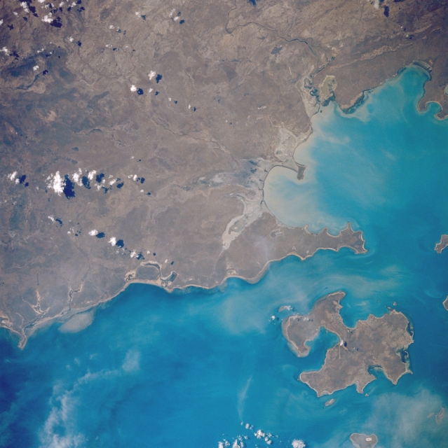 |
| STS035-076-070 Blue Mud Bay, Northern Territory, Australia December 1990 Located along the western edge of the Gulf of Carpentaria, Blue Mud Bay (right middle) is one of the larger embayments along the east coast of the Northern Territory. Bickerton Island is the irregular-shaped island in the image. Large tides wash over the coastal mud flats (gray areas along the coast) and produce muddy sediment plumes along the shoreline of the bay. |
| Images: | All Available Images Low-Resolution 302k |
|
| Mission: | STS035 |
|
| Roll - Frame: | 76 - 70 |
|
| Geographical Name: | AUSTRALIA-NT |
|
| Features: | BLUE MUD BAY |
|
| Center Lat x Lon: | 14S x 136.0E |
|
| Film Exposure: | N | N=Normal exposure, U=Under exposed, O=Over exposed, F=out of Focus |
| Percentage of Cloud Cover-CLDP: | 10 |
|
| Camera:: | HB |
|
| Camera Tilt: | 19 | LO=Low Oblique, HO=High Oblique, NV=Near Vertical |
| Camera Focal Length: | 250 |
|
| Nadir to Photo Center Direction: | E | The direction from the nadir to the center point, N=North, S=South, E=East, W=West |
| Stereo?: | Y | Y=Yes there is an adjacent picture of the same area, N=No there isn't |
| Orbit Number: | 94 |
|
| Date: | 19901208 | YYYYMMDD |
| Time: | 053441 | GMT HHMMSS |
| Nadir Lat: | 13.6S |
Latitude of suborbital point of spacecraft |
| Nadir Lon: | 135.0E |
Longitude of suborbital point of spacecraft |
| Sun Azimuth: | 250 | Clockwise angle in degrees from north to the sun measured at the nadir point |
| Space Craft Altitude: | 186 | nautical miles |
| Sun Elevation: | 50 | Angle in degrees between the horizon and the sun, measured at the nadir point |
| Land Views: | PLAIN, ISLAND |
|
| Water Views: | BAY |
|
| Atmosphere Views: | |
|
| Man Made Views: | |
|
| City Views: | |
|
Photo is not associated with any sequences | ||
| NASA Home Page |
JSC Home Page |
JSC Digital Image Collection |
Earth Science & Remote Sensing |
|
This service is provided by the International Space Station program and the JSC Earth Science & Remote Sensing Unit, ARES Division, Exploration Integration Science Directorate.

|