
Geographic Region: AUSTRALIA-WA
Feature: GEEGULLY CREEK
|
Geographic Region: AUSTRALIA-WA Feature: GEEGULLY CREEK |
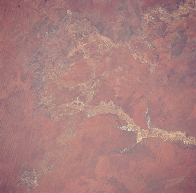 |
| STS035-076-066 Geegully Creek, Western Australia, Australia December 1990 Geegully Creek, a short tributary of the Fitzroy River in northern Western Australia, is an intermittent stream that drains northward from the Edgar Range. Numerous stream channels and a fairly wide floodplain are visible in this image of Geegully Creek. The floodplain also includes several dry lake beds (lighter-colored features seen as fingers extending out from the main stream channel). The parallel, linear pattern that cuts across the picture are east-west aligned sand ridges. Some of this grassy landscape shows unusual dark-light designs that have been produced by grass fires. |
| Images: | All Available Images Low-Resolution 282k |
|
| Mission: | STS035 |
|
| Roll - Frame: | 76 - 66 |
|
| Geographical Name: | AUSTRALIA-WA |
|
| Features: | GEEGULLY CREEK |
|
| Center Lat x Lon: | 19.5S x 123.5E |
|
| Film Exposure: | N | N=Normal exposure, U=Under exposed, O=Over exposed, F=out of Focus |
| Percentage of Cloud Cover-CLDP: | 0 |
|
| Camera:: | HB |
|
| Camera Tilt: | 28 | LO=Low Oblique, HO=High Oblique, NV=Near Vertical |
| Camera Focal Length: | 250 |
|
| Nadir to Photo Center Direction: | SW | The direction from the nadir to the center point, N=North, S=South, E=East, W=West |
| Stereo?: | Y | Y=Yes there is an adjacent picture of the same area, N=No there isn't |
| Orbit Number: | 94 |
|
| Date: | 19901208 | YYYYMMDD |
| Time: | 053142 | GMT HHMMSS |
| Nadir Lat: | 18.3S |
Latitude of suborbital point of spacecraft |
| Nadir Lon: | 124.6E |
Longitude of suborbital point of spacecraft |
| Sun Azimuth: | 255 | Clockwise angle in degrees from north to the sun measured at the nadir point |
| Space Craft Altitude: | 187 | nautical miles |
| Sun Elevation: | 61 | Angle in degrees between the horizon and the sun, measured at the nadir point |
| Land Views: | DUNE |
|
| Water Views: | RIVER, PLAYA |
|
| Atmosphere Views: | |
|
| Man Made Views: | |
|
| City Views: | |
|
Photo is not associated with any sequences | ||
| NASA Home Page |
JSC Home Page |
JSC Digital Image Collection |
Earth Science & Remote Sensing |
|
This service is provided by the International Space Station program and the JSC Earth Science & Remote Sensing Unit, ARES Division, Exploration Integration Science Directorate.

|