
Geographic Region: AUSTRALIA-WA
Feature: COAST-TURNER RIVER
|
Geographic Region: AUSTRALIA-WA Feature: COAST-TURNER RIVER |
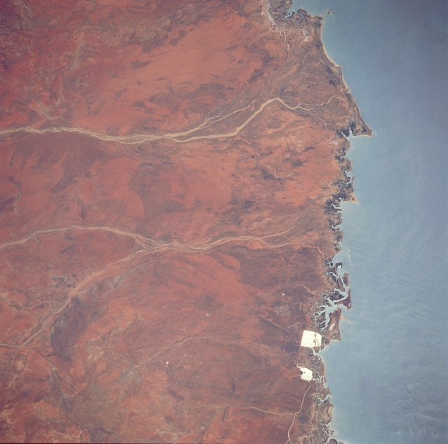 |
| STS035-076-054 Port Hedland Area, Western Australia, Australia December 1990 The two highly reflective features are part of a flourishing salt mining operation (salt evaporation-pans) along the shoreline in northern Western Australia. The two north flowing river systems (flow is to the right) are the Turner and the Yule River (most westerly). Although these rivers flow only intermittently through the arid region, the tropical rains that do fall during the summer months have sufficient flow to build sizable deltas (slightly darker, more vegetated landscape) along the coast. There is also a narrow band of mangrove forest (darker areas) along the coast. |
| Images: | All Available Images Low-Resolution 297k |
|
| Mission: | STS035 |
|
| Roll - Frame: | 76 - 54 |
|
| Geographical Name: | AUSTRALIA-WA |
|
| Features: | COAST-TURNER RIVER |
|
| Center Lat x Lon: | 20.5S x 118.5E |
|
| Film Exposure: | N | N=Normal exposure, U=Under exposed, O=Over exposed, F=out of Focus |
| Percentage of Cloud Cover-CLDP: | 0 |
|
| Camera:: | HB |
|
| Camera Tilt: | 28 | LO=Low Oblique, HO=High Oblique, NV=Near Vertical |
| Camera Focal Length: | 250 |
|
| Nadir to Photo Center Direction: | W | The direction from the nadir to the center point, N=North, S=South, E=East, W=West |
| Stereo?: | Y | Y=Yes there is an adjacent picture of the same area, N=No there isn't |
| Orbit Number: | 94 |
|
| Date: | 19901208 | YYYYMMDD |
| Time: | 053028 | GMT HHMMSS |
| Nadir Lat: | 20.1S |
Latitude of suborbital point of spacecraft |
| Nadir Lon: | 120.1E |
Longitude of suborbital point of spacecraft |
| Sun Azimuth: | 259 | Clockwise angle in degrees from north to the sun measured at the nadir point |
| Space Craft Altitude: | 187 | nautical miles |
| Sun Elevation: | 66 | Angle in degrees between the horizon and the sun, measured at the nadir point |
| Land Views: | COAST |
|
| Water Views: | RIVER |
|
| Atmosphere Views: | |
|
| Man Made Views: | MINING |
|
| City Views: | |
|
Photo is not associated with any sequences | ||
| NASA Home Page |
JSC Home Page |
JSC Digital Image Collection |
Earth Science & Remote Sensing |
|
This service is provided by the International Space Station program and the JSC Earth Science & Remote Sensing Unit, ARES Division, Exploration Integration Science Directorate.

|