
Geographic Region: AUSTRALIA-WA
Feature: COAST-MERMAID SOUND
|
Geographic Region: AUSTRALIA-WA Feature: COAST-MERMAID SOUND |
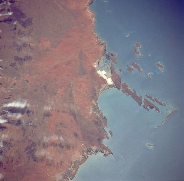 |
| STS035-076-050 Dampier Area, Western Australia, Australia December 1990 The highly reflective surfaces near the middle of the photograph show the location of evaporative pans where salt is being mined on the northwest coast of Western Australia. The Burrup Peninsula, the large peninsula pointing northward (right) has an abundance of prehistoric rock engravings. Part of the extensive Dampier Archipelago is visible along the coastline. This archipelago consists of 42 islands. The islands were formed approximately 7000 years ago when rising water from the melting glaciers (last Ice Age) flooded the coastal valleys. |
| Images: | All Available Images Low-Resolution 282k |
|
| Mission: | STS035 |
|
| Roll - Frame: | 76 - 50 |
|
| Geographical Name: | AUSTRALIA-WA |
|
| Features: | COAST-MERMAID SOUND |
|
| Center Lat x Lon: | 21S x 117.0E |
|
| Film Exposure: | N | N=Normal exposure, U=Under exposed, O=Over exposed, F=out of Focus |
| Percentage of Cloud Cover-CLDP: | 15 |
|
| Camera:: | HB |
|
| Camera Tilt: | 35 | LO=Low Oblique, HO=High Oblique, NV=Near Vertical |
| Camera Focal Length: | 250 |
|
| Nadir to Photo Center Direction: | W | The direction from the nadir to the center point, N=North, S=South, E=East, W=West |
| Stereo?: | Y | Y=Yes there is an adjacent picture of the same area, N=No there isn't |
| Orbit Number: | 94 |
|
| Date: | 19901208 | YYYYMMDD |
| Time: | 053011 | GMT HHMMSS |
| Nadir Lat: | 20.5S |
Latitude of suborbital point of spacecraft |
| Nadir Lon: | 119.1E |
Longitude of suborbital point of spacecraft |
| Sun Azimuth: | 259 | Clockwise angle in degrees from north to the sun measured at the nadir point |
| Space Craft Altitude: | 188 | nautical miles |
| Sun Elevation: | 67 | Angle in degrees between the horizon and the sun, measured at the nadir point |
| Land Views: | COAST, PENINSULA |
|
| Water Views: | |
|
| Atmosphere Views: | |
|
| Man Made Views: | MINING |
|
| City Views: | |
|
Photo is not associated with any sequences | ||
| NASA Home Page |
JSC Home Page |
JSC Digital Image Collection |
Earth Science & Remote Sensing |
|
This service is provided by the International Space Station program and the JSC Earth Science & Remote Sensing Unit, ARES Division, Exploration Integration Science Directorate.

|