
Geographic Region: AUSTRALIA-WA
Feature: COAST-NINGALOO REEF
|
Geographic Region: AUSTRALIA-WA Feature: COAST-NINGALOO REEF |
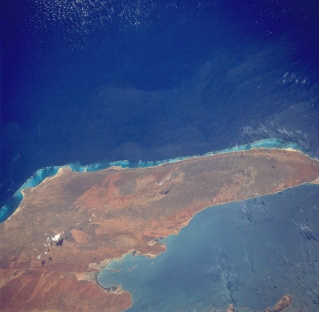 |
| STS035-76-44 North West Cape, Western Australia, Australia December 1990 This sizable peninsula forms the western border for the Exmouth Gulf of northwest Western Australia. A line of low mountains, known as the Cape Range, extends along the spine or north-south axis of the peninsula. Maximum elevation in these low mountains is 1099 feet (335 meters) above sea level. Some of the lighter colored, angular-looking designs indicate that the vegetative cover, mainly grasslands, has been modified by fires. The clearly defined Ningaloo Reef system borders the west coast of the peninsula. |
| Images: | All Available Images Low-Resolution 282k |
|
| Mission: | STS035 |
|
| Roll - Frame: | 76 - 44 |
|
| Geographical Name: | AUSTRALIA-WA |
|
| Features: | COAST-NINGALOO REEF |
|
| Center Lat x Lon: | 22S x 114.0E |
|
| Film Exposure: | N | N=Normal exposure, U=Under exposed, O=Over exposed, F=out of Focus |
| Percentage of Cloud Cover-CLDP: | 5 |
|
| Camera:: | HB |
|
| Camera Tilt: | 41 | LO=Low Oblique, HO=High Oblique, NV=Near Vertical |
| Camera Focal Length: | 250 |
|
| Nadir to Photo Center Direction: | W | The direction from the nadir to the center point, N=North, S=South, E=East, W=West |
| Stereo?: | Y | Y=Yes there is an adjacent picture of the same area, N=No there isn't |
| Orbit Number: | 94 |
|
| Date: | 19901208 | YYYYMMDD |
| Time: | 052933 | GMT HHMMSS |
| Nadir Lat: | 21.4S |
Latitude of suborbital point of spacecraft |
| Nadir Lon: | 116.7E |
Longitude of suborbital point of spacecraft |
| Sun Azimuth: | 261 | Clockwise angle in degrees from north to the sun measured at the nadir point |
| Space Craft Altitude: | 188 | nautical miles |
| Sun Elevation: | 70 | Angle in degrees between the horizon and the sun, measured at the nadir point |
| Land Views: | PENINSULA |
|
| Water Views: | BAY |
|
| Atmosphere Views: | |
|
| Man Made Views: | |
|
| City Views: | |
|
Photo is not associated with any sequences | ||
| NASA Home Page |
JSC Home Page |
JSC Digital Image Collection |
Earth Science & Remote Sensing |
|
This service is provided by the International Space Station program and the JSC Earth Science & Remote Sensing Unit, ARES Division, Exploration Integration Science Directorate.

|