
Geographic Region: AUSTRALIA-WA
Feature: COAST-LAKE MCLEOD
|
Geographic Region: AUSTRALIA-WA Feature: COAST-LAKE MCLEOD |
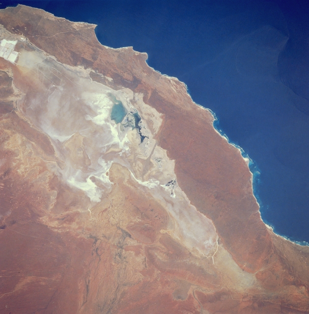 |
| STS035-076-040 Lake Macleod, West Australia, Australia December 1990 Lake Macleod, located approximately 43 miles (70 kilometers) north of the small town of Carnarvon, is normally a dry lake. At the time this photograph was taken there appears to be standing water in Lake Macleod (darker features near center of the image). Overall, the dry lake bed is a mosaic of saline alluvial plains with some shrublands and an assortment of sandy ridges, clay flats, and grasslands on and between red sand dunes. The light colored rectangular patterns (bottom left) are areas where salt mining operations are in progress. The southern end of Lake Macleod has been producing various quantities of salt since 1969. Much of the mined salt is exported to Pacific Rim countries. |
| Images: | All Available Images Low-Resolution 287k |
|
| Mission: | STS035 |
|
| Roll - Frame: | 76 - 40 |
|
| Geographical Name: | AUSTRALIA-WA |
|
| Features: | COAST-LAKE MCLEOD |
|
| Center Lat x Lon: | 24S x 113.5E |
|
| Film Exposure: | N | N=Normal exposure, U=Under exposed, O=Over exposed, F=out of Focus |
| Percentage of Cloud Cover-CLDP: | 0 |
|
| Camera:: | HB |
|
| Camera Tilt: | 33 | LO=Low Oblique, HO=High Oblique, NV=Near Vertical |
| Camera Focal Length: | 250 |
|
| Nadir to Photo Center Direction: | S | The direction from the nadir to the center point, N=North, S=South, E=East, W=West |
| Stereo?: | Y | Y=Yes there is an adjacent picture of the same area, N=No there isn't |
| Orbit Number: | 94 |
|
| Date: | 19901208 | YYYYMMDD |
| Time: | 052856 | GMT HHMMSS |
| Nadir Lat: | 22.2S |
Latitude of suborbital point of spacecraft |
| Nadir Lon: | 114.4E |
Longitude of suborbital point of spacecraft |
| Sun Azimuth: | 264 | Clockwise angle in degrees from north to the sun measured at the nadir point |
| Space Craft Altitude: | 188 | nautical miles |
| Sun Elevation: | 72 | Angle in degrees between the horizon and the sun, measured at the nadir point |
| Land Views: | PLAIN |
|
| Water Views: | PLAYA |
|
| Atmosphere Views: | |
|
| Man Made Views: | MINING |
|
| City Views: | |
|
Photo is not associated with any sequences | ||
| NASA Home Page |
JSC Home Page |
JSC Digital Image Collection |
Earth Science & Remote Sensing |
|
This service is provided by the International Space Station program and the JSC Earth Science & Remote Sensing Unit, ARES Division, Exploration Integration Science Directorate.

|