
Geographic Region: NICARAGUA
Feature: MANAGUA
|
Geographic Region: NICARAGUA Feature: MANAGUA |
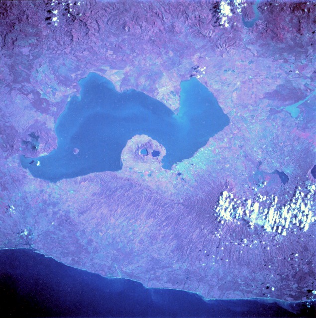 |
| STS034-88-8 Lake Managua, Nicaragua October 1989 Lake Managua, a large freshwater lake approximately 40 miles (65 kilometers) long and 15 miles (25 kilometers) wide, is the centerpiece of this near-vertical, color infrared photograph. The color infrared film allows differentiation of forested and nonforested areas and highlights various cultural features. The lake empties via the Tipitapa River into much larger Lake Nicaragua (not part of this photograph) to the southeast. The capital city of Managua, with a population of more than 500 000, is located along the southern shore of Lake Managua, the area with the highest population density in Nicaragua. The key to understanding the physical setting of Lake Managua is to note the numerous volcanic features aligned in a northwest-southeast axis. Momotombo, a stratovolcano, is located on the northwest end of the lake, and two water-filled calderas (Apoyegue and Jiloa volcanoes) are easily discernible on the Chiltepe Peninsula, which protrudes into Lake Managua. Two major earthquakes (1931 and 1972) devastated the Managua area. In addition to occasional volcanic activity, a crustal fracture (structural rift valley) has created a long, narrow depression east of the volcanic zone and west of the main body of mountains. This very active, unstable geologic area is the result of the subduction of the Cocos Plate by the Caribbean Plate. |
| Images: | All Available Images Low-Resolution 147k |
|
| Mission: | STS034 |
|
| Roll - Frame: | 88 - 8 |
|
| Geographical Name: | NICARAGUA |
|
| Features: | MANAGUA |
|
| Center Lat x Lon: | 12.0N x 86.5W |
|
| Film Exposure: | N | N=Normal exposure, U=Under exposed, O=Over exposed, F=out of Focus |
| Percentage of Cloud Cover-CLDP: | 5 |
|
| Camera:: | HB |
|
| Camera Tilt: | NV | LO=Low Oblique, HO=High Oblique, NV=Near Vertical |
| Camera Focal Length: | 250 |
|
| Nadir to Photo Center Direction: | SW | The direction from the nadir to the center point, N=North, S=South, E=East, W=West |
| Stereo?: | Y | Y=Yes there is an adjacent picture of the same area, N=No there isn't |
| Orbit Number: | 31 |
|
| Date: | 19891020 | YYYYMMDD |
| Time: | 140920 | GMT HHMMSS |
| Nadir Lat: | 13.6N |
Latitude of suborbital point of spacecraft |
| Nadir Lon: | 85.1W |
Longitude of suborbital point of spacecraft |
| Sun Azimuth: | 113 | Clockwise angle in degrees from north to the sun measured at the nadir point |
| Space Craft Altitude: | 179 | nautical miles |
| Sun Elevation: | 35 | Angle in degrees between the horizon and the sun, measured at the nadir point |
| Land Views: | VOLCANO, CRATER, MOUNTAIN |
|
| Water Views: | LAKE |
|
| Atmosphere Views: | |
|
| Man Made Views: | URBAN AREA, AGRICULTURE |
|
| City Views: | |
|
Photo is not associated with any sequences | ||
| NASA Home Page |
JSC Home Page |
JSC Digital Image Collection |
Earth Science & Remote Sensing |
|
This service is provided by the International Space Station program and the JSC Earth Science & Remote Sensing Unit, ARES Division, Exploration Integration Science Directorate.

|