
Geographic Region: USA-FLORIDA
Feature: LAKE OKEECHOBEE
|
Geographic Region: USA-FLORIDA Feature: LAKE OKEECHOBEE |
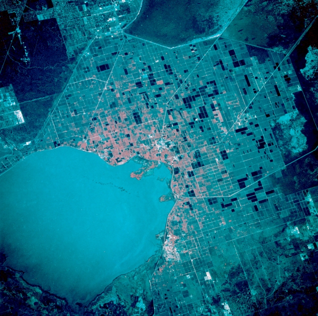 |
| STS034-088-022 Lake Okeechobee Basin, Florida, U.S.A. October 1989 Large cultivated sugarcane fields (rectangular patterns) are easily discriminated south and southeast of Lake Okeechobee. These flatlands in south-central Florida were part of Lake Okeechobee when it was much larger and produced an abundance of vegetation. As the shoreline receded to its present size, the decaying plants left a rich soil with a high humus content. Light, linear features extending south and southeast from the lake are part of a network of dikes and canals built by the U.S. Army Corps of Engineers to transport water to the east coast. Part of the Arthur R. Marshall-Loxahatchee National Wildlife Refuge is visible (right edge). |
| Images: | All Available Images Low-Resolution 398k |
|
| Mission: | STS034 |
|
| Roll - Frame: | 88 - 22 |
|
| Geographical Name: | USA-FLORIDA |
|
| Features: | LAKE OKEECHOBEE |
|
| Center Lat x Lon: | 26.5N x 80.5W |
|
| Film Exposure: | N | N=Normal exposure, U=Under exposed, O=Over exposed, F=out of Focus |
| Percentage of Cloud Cover-CLDP: | 0 |
|
| Camera:: | HB |
|
| Camera Tilt: | 25 | LO=Low Oblique, HO=High Oblique, NV=Near Vertical |
| Camera Focal Length: | 250 |
|
| Nadir to Photo Center Direction: | SE | The direction from the nadir to the center point, N=North, S=South, E=East, W=West |
| Stereo?: | N | Y=Yes there is an adjacent picture of the same area, N=No there isn't |
| Orbit Number: | 32 |
|
| Date: | 19891020 | YYYYMMDD |
| Time: | 154739 | GMT HHMMSS |
| Nadir Lat: | 27.5N |
Latitude of suborbital point of spacecraft |
| Nadir Lon: | 81.5W |
Longitude of suborbital point of spacecraft |
| Sun Azimuth: | 149 | Clockwise angle in degrees from north to the sun measured at the nadir point |
| Space Craft Altitude: | 179 | nautical miles |
| Sun Elevation: | 47 | Angle in degrees between the horizon and the sun, measured at the nadir point |
| Land Views: | PLAIN |
|
| Water Views: | LAKE, CANAL |
|
| Atmosphere Views: | |
|
| Man Made Views: | AGRICULTURE |
|
| City Views: | |
|
Photo is not associated with any sequences | ||
| NASA Home Page |
JSC Home Page |
JSC Digital Image Collection |
Earth Science & Remote Sensing |
|
This service is provided by the International Space Station program and the JSC Earth Science & Remote Sensing Unit, ARES Division, Exploration Integration Science Directorate.

|