Geographic Region: JAPAN
Feature: KYUSHU
|
Geographic Region: JAPAN Feature: KYUSHU |
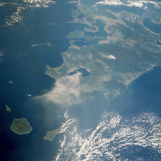 |
| STS034-084-036 Kyushu Island, Japan October 1989 The rugged physiography of Japan is captured in this low-oblique, north-looking photograph that shows most of Kyushu Island, Japan's southernmost large island. Much of Japan is mountainous and steep-sloped, geologically young, earthquake prone, and volcanic. Only about 18 percent of Japan's land is usable for human habitation; available arable land for farming is also at a premium. This photograph confirms the lack of habitable space--the extensive darker green areas are hills and mountains; many of the regions have peaks that exceed 3000 feet (915 meters). Highly reflective urban areas appear primarily along the coast and in some valleys. Mount Sakura-jima, located on a peninsula in Kagoshima Bay, has almost daily, and sometimes explosive, eruptions; its ash plume is visible in this photograph. |
| Images: | All Available Images Low-Resolution 130k |
|
| Mission: | STS034 |
|
| Roll - Frame: | 84 - 36 |
|
| Geographical Name: | JAPAN |
|
| Features: | KYUSHU |
|
| Center Lat x Lon: | 31.5N x 131.0E |
|
| Film Exposure: | N | N=Normal exposure, U=Under exposed, O=Over exposed, F=out of Focus |
| Percentage of Cloud Cover-CLDP: | 30 |
|
| Camera:: | HB |
|
| Camera Tilt: | 45 | LO=Low Oblique, HO=High Oblique, NV=Near Vertical |
| Camera Focal Length: | 100 |
|
| Nadir to Photo Center Direction: | N | The direction from the nadir to the center point, N=North, S=South, E=East, W=West |
| Stereo?: | N | Y=Yes there is an adjacent picture of the same area, N=No there isn't |
| Orbit Number: | 54 |
|
| Date: | 19891022 | YYYYMMDD |
| Time: | 010347 | GMT HHMMSS |
| Nadir Lat: | 28.5N |
Latitude of suborbital point of spacecraft |
| Nadir Lon: | 131.6E |
Longitude of suborbital point of spacecraft |
| Sun Azimuth: | 140 | Clockwise angle in degrees from north to the sun measured at the nadir point |
| Space Craft Altitude: | 180 | nautical miles |
| Sun Elevation: | 41 | Angle in degrees between the horizon and the sun, measured at the nadir point |
| Land Views: | COAST, ISLAND, VOLCANO, FOREST, PENINSULA, MOUNTAIN |
|
| Water Views: | BAY, ESTUARY |
|
| Atmosphere Views: | SMOKE, PLUME |
|
| Man Made Views: | URBAN AREA |
|
| City Views: | |
|
Photo is not associated with any sequences | ||
| NASA Home Page |
JSC Home Page |
JSC Digital Image Collection |
Earth Science & Remote Sensing |
|
This service is provided by the International Space Station program and the JSC Earth Science & Remote Sensing Unit, ARES Division, Exploration Integration Science Directorate.

|