
Geographic Region: USA-NORTH CAROLINA
Feature: PAMLICO RIVER
|
Geographic Region: USA-NORTH CAROLINA Feature: PAMLICO RIVER |
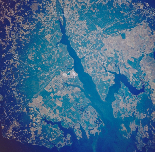 |
| STS034-083-067 Pamlico River, North Carolina, U.S.A. October 1989 The east-southeast-flowing Pamlico River, shown here as a wide estuary, is visible as it empties into Pamlico Sound along the east coast of North Carolina. The broad estuary of the much shorter Pungo River can be seen as it flows into the north side of the Pamlico River near its mouth. The light colored area in the center of the image is an operating phosphate mine and a single runway. Most of the lighter colored landscape, consisting of angular shaped field patterns, are used for agriculture; while the darker terrain tends to be extensive woodlands. |
| Images: | All Available Images Low-Resolution 405k |
|
| Mission: | STS034 |
|
| Roll - Frame: | 83 - 67 |
|
| Geographical Name: | USA-NORTH CAROLINA |
|
| Features: | PAMLICO RIVER |
|
| Center Lat x Lon: | 35.5N x 77W |
|
| Film Exposure: | N | N=Normal exposure, U=Under exposed, O=Over exposed, F=out of Focus |
| Percentage of Cloud Cover-CLDP: | 0 |
|
| Camera:: | HB |
|
| Camera Tilt: | 22 | LO=Low Oblique, HO=High Oblique, NV=Near Vertical |
| Camera Focal Length: | 250 |
|
| Nadir to Photo Center Direction: | N | The direction from the nadir to the center point, N=North, S=South, E=East, W=West |
| Stereo?: | N | Y=Yes there is an adjacent picture of the same area, N=No there isn't |
| Orbit Number: | 49 |
|
| Date: | 19891021 | YYYYMMDD |
| Time: | 173837 | GMT HHMMSS |
| Nadir Lat: | 34.4N |
Latitude of suborbital point of spacecraft |
| Nadir Lon: | 76.5W |
Longitude of suborbital point of spacecraft |
| Sun Azimuth: | 196 | Clockwise angle in degrees from north to the sun measured at the nadir point |
| Space Craft Altitude: | 177 | nautical miles |
| Sun Elevation: | 43 | Angle in degrees between the horizon and the sun, measured at the nadir point |
| Land Views: | PLAIN |
|
| Water Views: | RIVER, ESTUARY |
|
| Atmosphere Views: | |
|
| Man Made Views: | MINING, AGRICULTURE |
|
| City Views: | |
|
Photo is not associated with any sequences | ||
| NASA Home Page |
JSC Home Page |
JSC Digital Image Collection |
Earth Science & Remote Sensing |
|
This service is provided by the International Space Station program and the JSC Earth Science & Remote Sensing Unit, ARES Division, Exploration Integration Science Directorate.

|