
Geographic Region: CHINA
Feature: DONGTING L, XIANG R, AGR
|
Geographic Region: CHINA Feature: DONGTING L, XIANG R, AGR |
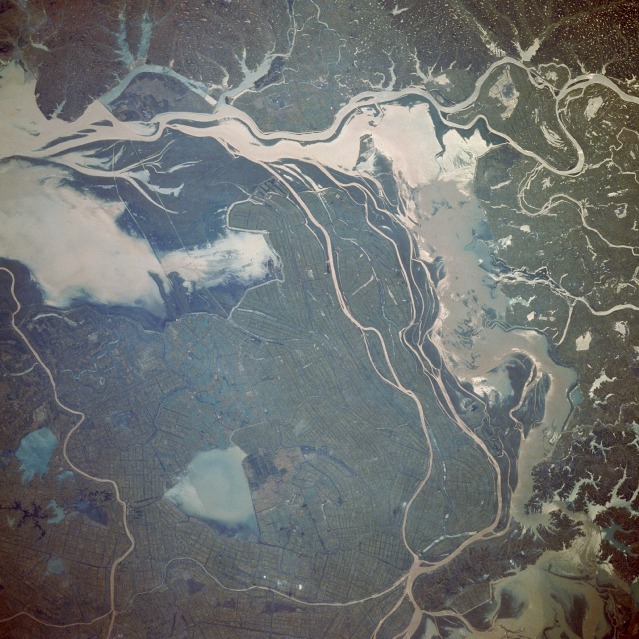 |
| STS034-078-031 Chang Jiang (River), China October 1989 Located approximately 50 miles (80 kilometers) north of Changsha in northern Hunan Province, this complex, hydrologically controlled lake region looks almost surreal. Identifying specific rivers that enter this region is difficult because of many crisscrossing rivers, lakes, irrigation canals, and ditches. Two major rivers, the east-flowing Yuan River and the north-flowing Xiang River, merge near the eastern edge of the photograph and flow northeastward into the mighty Chang (Yangtze) River (not shown in this photograph). Triangular Datong Lake (northern area of the photograph) is surrounded by extensive, cultivated field patterns, most of which are presumed to be irrigated rice paddies. The two larger lakes are known collectively as Lake Dongting. |
| Images: | All Available Images Low-Resolution 148k |
|
| Mission: | STS034 |
|
| Roll - Frame: | 78 - 31 |
|
| Geographical Name: | CHINA |
|
| Features: | DONGTING L, XIANG R, AGR |
|
| Center Lat x Lon: | 29.0N x 112.0E |
|
| Film Exposure: | N | N=Normal exposure, U=Under exposed, O=Over exposed, F=out of Focus |
| Percentage of Cloud Cover-CLDP: | 0 |
|
| Camera:: | HB |
|
| Camera Tilt: | 22 | LO=Low Oblique, HO=High Oblique, NV=Near Vertical |
| Camera Focal Length: | 250 |
|
| Nadir to Photo Center Direction: | S | The direction from the nadir to the center point, N=North, S=South, E=East, W=West |
| Stereo?: | N | Y=Yes there is an adjacent picture of the same area, N=No there isn't |
| Orbit Number: | 24 |
|
| Date: | 19891020 | YYYYMMDD |
| Time: | 034423 | GMT HHMMSS |
| Nadir Lat: | 30.2N |
Latitude of suborbital point of spacecraft |
| Nadir Lon: | 112.2E |
Longitude of suborbital point of spacecraft |
| Sun Azimuth: | 168 | Clockwise angle in degrees from north to the sun measured at the nadir point |
| Space Craft Altitude: | 178 | nautical miles |
| Sun Elevation: | 48 | Angle in degrees between the horizon and the sun, measured at the nadir point |
| Land Views: | BASIN, PLAIN, VALLEY |
|
| Water Views: | LAKE, RIVER, SEDIMENT |
|
| Atmosphere Views: | |
|
| Man Made Views: | AGRICULTURE |
|
| City Views: | |
|
Photo is not associated with any sequences | ||
| NASA Home Page |
JSC Home Page |
JSC Digital Image Collection |
Earth Science & Remote Sensing |
|
This service is provided by the International Space Station program and the JSC Earth Science & Remote Sensing Unit, ARES Division, Exploration Integration Science Directorate.

|