Geographic Region: INDIA
Feature: DELTAS-GODAVARI/KRISHNA
|
Geographic Region: INDIA Feature: DELTAS-GODAVARI/KRISHNA |
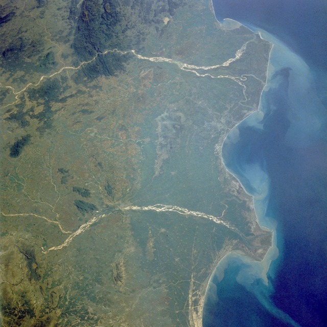 |
| STS034-077-029 Godavari and Krishna River Deltas, India October 1989 The mouths of the Godavari River (east) and the Krishna River (west) empty into the Bay of Bengal in this low-oblique, northwest-looking photograph. The Godavari River, 900 miles (1450 kilometers) long, rises in the Western Ghats and flows across the Deccan Plateau toward the Bay of Bengal in eastern India. Below the city of Rajahmundry, the river divides into two streams that form the huge delta, which is the site of some of the earliest European settlements in India. The Krishna River, more than 800 miles (1290 kilometers) long, also rises in the Western Ghats only 40 miles (64 kilometers) from the Arabian Sea. The river also traverses the Deccan Plateau and empties into the Bay of Bengal southwest of the Godavari River Delta. The two rivers have several common characteristics--they are quite wide and have conspicuous deltas, both have heavy discharges of water during the monsoon season (June to early September) followed by low discharges during the dry season (October through late May), both discharge sediment into the Bay of Bengal, and both are sacred rivers of the Hindu religion. |
| Images: | All Available Images Low-Resolution 125k |
|
| Mission: | STS034 |
|
| Roll - Frame: | 77 - 29 |
|
| Geographical Name: | INDIA |
|
| Features: | DELTAS-GODAVARI/KRISHNA |
|
| Center Lat x Lon: | 17.0N x 81.0E |
|
| Film Exposure: | N | N=Normal exposure, U=Under exposed, O=Over exposed, F=out of Focus |
| Percentage of Cloud Cover-CLDP: | 0 |
|
| Camera:: | HB |
|
| Camera Tilt: | LO | LO=Low Oblique, HO=High Oblique, NV=Near Vertical |
| Camera Focal Length: | 100 |
|
| Nadir to Photo Center Direction: | The direction from the nadir to the center point, N=North, S=South, E=East, W=West |
|
| Stereo?: | N | Y=Yes there is an adjacent picture of the same area, N=No there isn't |
| Orbit Number: | |
|
| Date: | 198910__ | YYYYMMDD |
| Time: | GMT HHMMSS |
|
| Nadir Lat: | N |
Latitude of suborbital point of spacecraft |
| Nadir Lon: | E |
Longitude of suborbital point of spacecraft |
| Sun Azimuth: | Clockwise angle in degrees from north to the sun measured at the nadir point |
|
| Space Craft Altitude: | nautical miles |
|
| Sun Elevation: | Angle in degrees between the horizon and the sun, measured at the nadir point |
|
| Land Views: | COAST, PLAIN |
|
| Water Views: | RIVER, DELTA, BAY, SEDIMENT |
|
| Atmosphere Views: | |
|
| Man Made Views: | |
|
| City Views: | |
|
Photo is not associated with any sequences | ||
| NASA Home Page |
JSC Home Page |
JSC Digital Image Collection |
Earth Science & Remote Sensing |
|
This service is provided by the International Space Station program and the JSC Earth Science & Remote Sensing Unit, ARES Division, Exploration Integration Science Directorate.

|