Geographic Region: PUERTO RICO
Feature: ENTIRE IS,SAN JUAN,PONCE
|
Geographic Region: PUERTO RICO Feature: ENTIRE IS,SAN JUAN,PONCE |
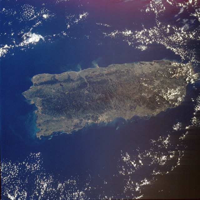 |
| STS034-76-88 Puerto Rico October 1989 The island of Puerto Rico, lying east-west, is slightly more than 100 miles (160 kilometers) long, and the average north-south width is about 35 miles (56 kilometers). More than three-fourths of Puerto Rico's land area consists of mountains and hills. The main chain of mountains running lengthwise is called the Cordillera Central in the west and the Sierra de Cayey in the east. Average land elevations are about 3000 feet (900 meters) above sea level, with the highest peak, Cerro de Punta at 4389 feet (1338 meters), located near the center of the photograph. The remainder of the island consists of lowlands and coastal plains. The two major cities of San Juan (estimated population 500 000) and Ponce (estimated population 200 000) are visible in the photograph. San Juan, the capital, is a port city on the north side of the island toward the eastern end, and Ponce is the major port city on the south side near the middle of the island. Note the sediment runoff from Puerto Rico that is occurring one month after the passage of Hurricane Hugo. The turbid plumes are from freshwater runoff, especially along the northern coast. |
| Images: | All Available Images Low-Resolution 138k |
|
| Mission: | STS034 |
|
| Roll - Frame: | 76 - 88 |
|
| Geographical Name: | PUERTO RICO |
|
| Features: | ENTIRE IS,SAN JUAN,PONCE |
|
| Center Lat x Lon: | 18.0N x 66.5W |
|
| Film Exposure: | U | N=Normal exposure, U=Under exposed, O=Over exposed, F=out of Focus |
| Percentage of Cloud Cover-CLDP: | 25 |
|
| Camera:: | HB |
|
| Camera Tilt: | 22 | LO=Low Oblique, HO=High Oblique, NV=Near Vertical |
| Camera Focal Length: | 100 |
|
| Nadir to Photo Center Direction: | NE | The direction from the nadir to the center point, N=North, S=South, E=East, W=West |
| Stereo?: | Y | Y=Yes there is an adjacent picture of the same area, N=No there isn't |
| Orbit Number: | 46 |
|
| Date: | 19891021 | YYYYMMDD |
| Time: | 125130 | GMT HHMMSS |
| Nadir Lat: | 17.0N |
Latitude of suborbital point of spacecraft |
| Nadir Lon: | 67.2W |
Longitude of suborbital point of spacecraft |
| Sun Azimuth: | 115 | Clockwise angle in degrees from north to the sun measured at the nadir point |
| Space Craft Altitude: | 179 | nautical miles |
| Sun Elevation: | 32 | Angle in degrees between the horizon and the sun, measured at the nadir point |
| Land Views: | COAST, FOREST, ISLAND, MOUNTAIN, PLAIN |
|
| Water Views: | BAY, SEA, OCEAN, SEDIMENT |
|
| Atmosphere Views: | |
|
| Man Made Views: | URBAN AREA, MINING |
|
| City Views: | |
|
Photo is not associated with any sequences | ||
| NASA Home Page |
JSC Home Page |
JSC Digital Image Collection |
Earth Science & Remote Sensing |
|
This service is provided by the International Space Station program and the JSC Earth Science & Remote Sensing Unit, ARES Division, Exploration Integration Science Directorate.

|