
Geographic Region: MEXICO
Feature: RIO GRANDE,AMISTAD RES.
|
Geographic Region: MEXICO Feature: RIO GRANDE,AMISTAD RES. |
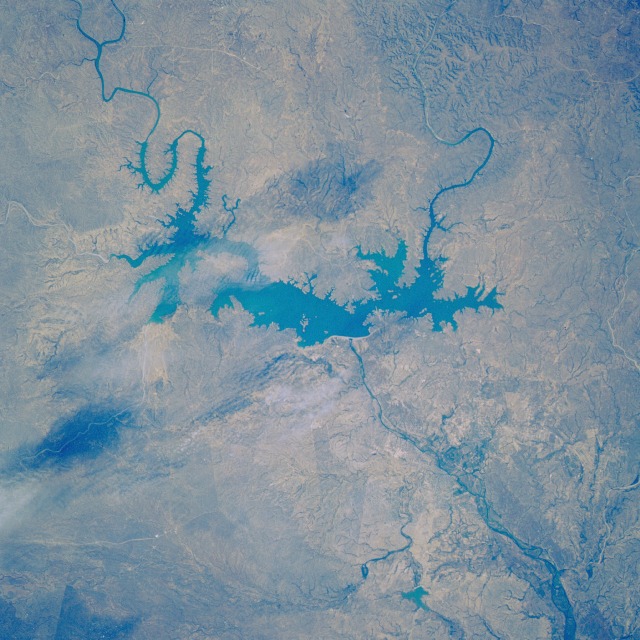 |
| STS034-074-101 International Amistad Reservoir and Del Rio, Texas, U.S.A. October 1989 Located on the Rio Grande in southwest Texas at the Texas-Mexico border, the International Amistad Reservoir was completed in 1969 as an international flood control project, which can be seen in this north-looking, low-oblique photograph. In the photograph two rivers are visible as they enter the International Amistad Reservoir--the Pecos River northwest of the lake and Devils River to the north. The dam and reservoir support the surrounding region--both Mexico and Texas--with hydroelectric power for municipalities and industry and irrigation water for agricultural crops. Southeast of the dam and barely discernible in the photograph is the small city of Del Rio, Texas. A port of entry to the United States from Mexico, Del Rio is the marketing and distribution center for the region. Agriculture is the main industry in the area, with products including alfalfa, truck crops, and fruits; sheep grazing and wool production are also important. Laughlin Air Force Base, a major jet training command located east of the city, is another major employer in the region. |
| Images: | All Available Images Low-Resolution 139k |
|
| Mission: | STS034 |
|
| Roll - Frame: | 74 - 101 |
|
| Geographical Name: | MEXICO |
|
| Features: | RIO GRANDE,AMISTAD RES. |
|
| Center Lat x Lon: | 29.5N x 101W |
|
| Film Exposure: | N | N=Normal exposure, U=Under exposed, O=Over exposed, F=out of Focus |
| Percentage of Cloud Cover-CLDP: | 15 |
|
| Camera:: | HB |
|
| Camera Tilt: | 12 | LO=Low Oblique, HO=High Oblique, NV=Near Vertical |
| Camera Focal Length: | 250 |
|
| Nadir to Photo Center Direction: | E | The direction from the nadir to the center point, N=North, S=South, E=East, W=West |
| Stereo?: | N | Y=Yes there is an adjacent picture of the same area, N=No there isn't |
| Orbit Number: | 67 |
|
| Date: | 19891022 | YYYYMMDD |
| Time: | 205822 | GMT HHMMSS |
| Nadir Lat: | 29.5N |
Latitude of suborbital point of spacecraft |
| Nadir Lon: | 101.6W |
Longitude of suborbital point of spacecraft |
| Sun Azimuth: | 226 | Clockwise angle in degrees from north to the sun measured at the nadir point |
| Space Craft Altitude: | 174 | nautical miles |
| Sun Elevation: | 36 | Angle in degrees between the horizon and the sun, measured at the nadir point |
| Land Views: | PLATEAU, MOUNTAIN, VALLEY |
|
| Water Views: | RIVER, RESERVOIR |
|
| Atmosphere Views: | |
|
| Man Made Views: | DAM, AGRICULTURE |
|
| City Views: | |
|
Photo is not associated with any sequences | ||
| NASA Home Page |
JSC Home Page |
JSC Digital Image Collection |
Earth Science & Remote Sensing |
|
This service is provided by the International Space Station program and the JSC Earth Science & Remote Sensing Unit, ARES Division, Exploration Integration Science Directorate.

|