
Geographic Region: USA-TEXAS
Feature: WACO, BRAZOS RIVER
|
Geographic Region: USA-TEXAS Feature: WACO, BRAZOS RIVER |
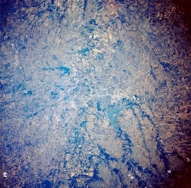 |
| STS034-073-071 Waco, Texas, U.S.A. October 1989 Visible in this photograph are a segment of Interstate Highway 35; the southeast-flowing Brazos River passing under Interstate 35 in the center of Waco; and Lake Waco west of downtown with its two major feeder tributaries that are part of the Brazos River watershed. Apparent southeast of Waco are cultivated field patterns along the meandering Brazos River and its floodplain; two smaller reservoirs east of Interstate 35; and east-west U.S. Highway 84 as it curves around the south side of Lake Waco. |
| Images: | All Available Images Low-Resolution 444k |
|
| Mission: | STS034 |
|
| Roll - Frame: | 73 - 71 |
|
| Geographical Name: | USA-TEXAS |
|
| Features: | WACO, BRAZOS RIVER |
|
| Center Lat x Lon: | 31.5N x 97W |
|
| Film Exposure: | N | N=Normal exposure, U=Under exposed, O=Over exposed, F=out of Focus |
| Percentage of Cloud Cover-CLDP: | 0 |
|
| Camera:: | HB |
|
| Camera Tilt: | 14 | LO=Low Oblique, HO=High Oblique, NV=Near Vertical |
| Camera Focal Length: | 250 |
|
| Nadir to Photo Center Direction: | N | The direction from the nadir to the center point, N=North, S=South, E=East, W=West |
| Stereo?: | N | Y=Yes there is an adjacent picture of the same area, N=No there isn't |
| Orbit Number: | 20 |
|
| Date: | 19891019 | YYYYMMDD |
| Time: | 215448 | GMT HHMMSS |
| Nadir Lat: | 30.8N |
Latitude of suborbital point of spacecraft |
| Nadir Lon: | 96.9W |
Longitude of suborbital point of spacecraft |
| Sun Azimuth: | 241 | Clockwise angle in degrees from north to the sun measured at the nadir point |
| Space Craft Altitude: | 170 | nautical miles |
| Sun Elevation: | 22 | Angle in degrees between the horizon and the sun, measured at the nadir point |
| Land Views: | RANGE, PLAIN |
|
| Water Views: | RIVER, RESERVOIR |
|
| Atmosphere Views: | |
|
| Man Made Views: | HIGHWAY |
|
| City Views: | |
|
Photo is not associated with any sequences | ||
| NASA Home Page |
JSC Home Page |
JSC Digital Image Collection |
Earth Science & Remote Sensing |
|
This service is provided by the International Space Station program and the JSC Earth Science & Remote Sensing Unit, ARES Division, Exploration Integration Science Directorate.

|