
Geographic Region: MYANMAR (BURMA)
Feature: MAYU RIVER-MOUNTAINS
|
Geographic Region: MYANMAR (BURMA) Feature: MAYU RIVER-MOUNTAINS |
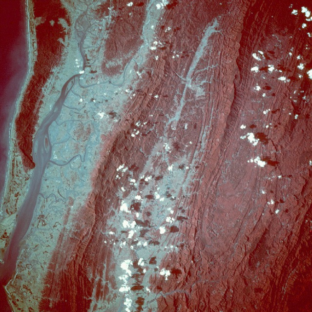 |
| STS033-92-72 Mayu and Naf River Valleys, Myanmar/Bangladesh November 1989 This color-infrared near-vertical view shows the mouth of the Naf River (left edge) and the upper Mayu River valley (center). The western linear folds of the Arakan Range separate the two river valleys. The water on the far left center and upper left of the image is the Bay of Bengal. The Naf River Valley is mostly an estuary of marsh and swamplands inter-dispersed with agricultural lands. The river course follows the Bangladesh-Myanmar border. The Mayu River has a larger catchment area, and here we see its upstream section; it continues to drain southward (bottom center) before its mouth widens into the Bay of Bengal just north of the city of Sittwe (not seen in this photograph). Forests cover most of the high slopes of the mountains with grasslands mixed with agriculture covering the lower slopes. Despite the dense forest cover of the hills and mountains, anticlinal and synclinal structural patterns are shown clearly. The Arakan Range is part of a long chain of ranges that form at the margin of the Indian plate and the Asian plate. |
| Images: | All Available Images Low-Resolution 176k |
|
| Mission: | STS033 |
|
| Roll - Frame: | 92 - 72 |
|
| Geographical Name: | MYANMAR (BURMA) |
|
| Features: | MAYU RIVER-MOUNTAINS |
|
| Center Lat x Lon: | 21.0N x 92.5E |
|
| Film Exposure: | N | N=Normal exposure, U=Under exposed, O=Over exposed, F=out of Focus |
| Percentage of Cloud Cover-CLDP: | 10 |
|
| Camera:: | HB |
|
| Camera Tilt: | 12 | LO=Low Oblique, HO=High Oblique, NV=Near Vertical |
| Camera Focal Length: | 250 |
|
| Nadir to Photo Center Direction: | NW | The direction from the nadir to the center point, N=North, S=South, E=East, W=West |
| Stereo?: | Y | Y=Yes there is an adjacent picture of the same area, N=No there isn't |
| Orbit Number: | 53 |
|
| Date: | 19891126 | YYYYMMDD |
| Time: | 080704 | GMT HHMMSS |
| Nadir Lat: | 20.7N |
Latitude of suborbital point of spacecraft |
| Nadir Lon: | 92.9E |
Longitude of suborbital point of spacecraft |
| Sun Azimuth: | 224 | Clockwise angle in degrees from north to the sun measured at the nadir point |
| Space Craft Altitude: | 142 | nautical miles |
| Sun Elevation: | 34 | Angle in degrees between the horizon and the sun, measured at the nadir point |
| Land Views: | HILL, FOREST, PLAIN |
|
| Water Views: | RIVER, SWAMP |
|
| Atmosphere Views: | |
|
| Man Made Views: | |
|
| City Views: | |
|
Photo is not associated with any sequences | ||
| NASA Home Page |
JSC Home Page |
JSC Digital Image Collection |
Earth Science & Remote Sensing |
|
This service is provided by the International Space Station program and the JSC Earth Science & Remote Sensing Unit, ARES Division, Exploration Integration Science Directorate.

|