
Geographic Region: AUSTRALIA-WA
Feature: LAKE ARGYLE
|
Geographic Region: AUSTRALIA-WA Feature: LAKE ARGYLE |
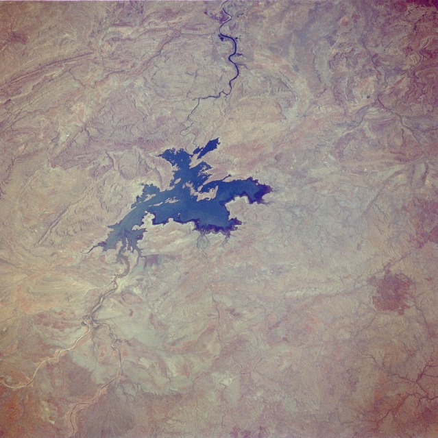 |
| STS033-082-021 Ord River and Lake Argyle, Western Australia November 1989 Lake Argyle and the rugged eastern portion of the Kimberley Plateau are visible in this low-oblique, north-northwest-looking photograph. Lake Argyle is part of the Ord River irrigation scheme, which provides a consistent supply of water for agriculture in this region. Because of the monsoonal climate, the region receives rainfall approximately 4 months of the year. The Ord River rises in the high Kimberley Plateau near the Durack Range (not visible in the photograph) and flows generally northward 200 miles (320 kilometers) before emptying into the Joseph Bonaparte Gulf near the city of Wyndham (not visible in the photograph). The Kimberley Plateau, once a limestone and coral bank larger than the present Great Barrier Reef, comprises a number of varied ranges, most of which are composed of rugged sandstone dissected by deep gorges. The aborigine word for the Kimberley is Wandjima, "the land of the wind and the water." Population is sparse, and transportation routes are almost nonexistent in this hot, desolate wilderness. |
| Images: | All Available Images Low-Resolution 133k |
|
| Mission: | STS033 |
|
| Roll - Frame: | 82 - 21 |
|
| Geographical Name: | AUSTRALIA-WA |
|
| Features: | LAKE ARGYLE |
|
| Center Lat x Lon: | 17.5S x 129.0E |
|
| Film Exposure: | N | N=Normal exposure, U=Under exposed, O=Over exposed, F=out of Focus |
| Percentage of Cloud Cover-CLDP: | 0 |
|
| Camera:: | HB |
|
| Camera Tilt: | 14 | LO=Low Oblique, HO=High Oblique, NV=Near Vertical |
| Camera Focal Length: | 250 |
|
| Nadir to Photo Center Direction: | N | The direction from the nadir to the center point, N=North, S=South, E=East, W=West |
| Stereo?: | N | Y=Yes there is an adjacent picture of the same area, N=No there isn't |
| Orbit Number: | 32 |
|
| Date: | 19891125 | YYYYMMDD |
| Time: | 005735 | GMT HHMMSS |
| Nadir Lat: | 18.5S |
Latitude of suborbital point of spacecraft |
| Nadir Lon: | 129.1E |
Longitude of suborbital point of spacecraft |
| Sun Azimuth: | 100 | Clockwise angle in degrees from north to the sun measured at the nadir point |
| Space Craft Altitude: | 241 | nautical miles |
| Sun Elevation: | 59 | Angle in degrees between the horizon and the sun, measured at the nadir point |
| Land Views: | PLATEAU, RANGE |
|
| Water Views: | RIVER, LAKE |
|
| Atmosphere Views: | |
|
| Man Made Views: | |
|
| City Views: | |
|
Photo is not associated with any sequences | ||
| NASA Home Page |
JSC Home Page |
JSC Digital Image Collection |
Earth Science & Remote Sensing |
|
This service is provided by the International Space Station program and the JSC Earth Science & Remote Sensing Unit, ARES Division, Exploration Integration Science Directorate.

|