
Geographic Region: AUSTRALIA-NT
Feature: THE ALBERGA R.
|
Geographic Region: AUSTRALIA-NT Feature: THE ALBERGA R. |
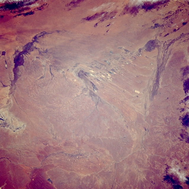 |
| STS033-081-001 Alberga Creek, South Australia, Australia November 1989 Located in the southeast corner of the Simpson Desert in central Australia, the Alberga Creek distributary channels are visible as dark lines that fan out near the right upper edge of the image. These streams have their headwater areas as well as their final distributary channels in the desert. This creek can be considered part of the much larger Lake Eyre drainage basin, although it is doubtful if any water ever makes it from Alberga Creek to Lake Eyre. Alberga Creek is one of literally hundreds of stream channels that criss-cross the expansive interior basin of Australia. The north-south oriented, lighter features near center of the picture are small dry lake beds which have formed between linear dunes. The darker arcing feature along the left side of the picture is another stream channel where some type of plant life exists. The subtle dendritic drainage patterns west of the linear dry lake beds are generated by water from rare rains flowing off of the slightly elevated terrain. |
| Images: | All Available Images Low-Resolution 348k |
|
| Mission: | STS033 |
|
| Roll - Frame: | 81 - 1 |
|
| Geographical Name: | AUSTRALIA-NT |
|
| Features: | THE ALBERGA R. |
|
| Center Lat x Lon: | 27S x 136.0E |
|
| Film Exposure: | N | N=Normal exposure, U=Under exposed, O=Over exposed, F=out of Focus |
| Percentage of Cloud Cover-CLDP: | 5 |
|
| Camera:: | HB |
|
| Camera Tilt: | 15 | LO=Low Oblique, HO=High Oblique, NV=Near Vertical |
| Camera Focal Length: | 250 |
|
| Nadir to Photo Center Direction: | SE | The direction from the nadir to the center point, N=North, S=South, E=East, W=West |
| Stereo?: | N | Y=Yes there is an adjacent picture of the same area, N=No there isn't |
| Orbit Number: | 46 |
|
| Date: | 19891125 | YYYYMMDD |
| Time: | 222400 | GMT HHMMSS |
| Nadir Lat: | 25.9S |
Latitude of suborbital point of spacecraft |
| Nadir Lon: | 135.3E |
Longitude of suborbital point of spacecraft |
| Sun Azimuth: | 100 | Clockwise angle in degrees from north to the sun measured at the nadir point |
| Space Craft Altitude: | 285 | nautical miles |
| Sun Elevation: | 30 | Angle in degrees between the horizon and the sun, measured at the nadir point |
| Land Views: | DESERT |
|
| Water Views: | RIVER, PLAYA |
|
| Atmosphere Views: | |
|
| Man Made Views: | |
|
| City Views: | |
|
Photo is not associated with any sequences | ||
| NASA Home Page |
JSC Home Page |
JSC Digital Image Collection |
Earth Science & Remote Sensing |
|
This service is provided by the International Space Station program and the JSC Earth Science & Remote Sensing Unit, ARES Division, Exploration Integration Science Directorate.

|