
Geographic Region: AUSTRALIA-WA
Feature: CAMBRIDGE GULF
|
Geographic Region: AUSTRALIA-WA Feature: CAMBRIDGE GULF |
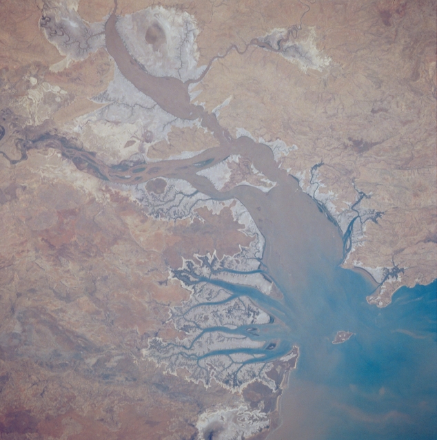 |
| STS033-079-035 Cambridge Gulf, Western Australia, Australia November 1989 Sediment-laden Cambridge Gulf can be seen emptying into the southwest corner of the much larger Joseph Bonaparte Gulf onthe north coast of Australia . Much of this coastal zone consists of saline tidal flats (lighter colored, grayish looking area). Several short flowing rivers drain into the Cambridge Gulf bringing water and light brown sediment from the Kimberley Plateau south of the gulf. Several distributary channels of the Ord River are visible (left center part of image) where the river discharges into the southeast side of Cambridge Gulf. |
| Images: | All Available Images Low-Resolution 293k |
|
| Mission: | STS033 |
|
| Roll - Frame: | 79 - 35 |
|
| Geographical Name: | AUSTRALIA-WA |
|
| Features: | CAMBRIDGE GULF |
|
| Center Lat x Lon: | 15S x 128.0E |
|
| Film Exposure: | N | N=Normal exposure, U=Under exposed, O=Over exposed, F=out of Focus |
| Percentage of Cloud Cover-CLDP: | 0 |
|
| Camera:: | HB |
|
| Camera Tilt: | 20 | LO=Low Oblique, HO=High Oblique, NV=Near Vertical |
| Camera Focal Length: | 250 |
|
| Nadir to Photo Center Direction: | N | The direction from the nadir to the center point, N=North, S=South, E=East, W=West |
| Stereo?: | N | Y=Yes there is an adjacent picture of the same area, N=No there isn't |
| Orbit Number: | 17 |
|
| Date: | 19891124 | YYYYMMDD |
| Time: | 015412 | GMT HHMMSS |
| Nadir Lat: | 16.3S |
Latitude of suborbital point of spacecraft |
| Nadir Lon: | 128.1E |
Longitude of suborbital point of spacecraft |
| Sun Azimuth: | 106 | Clockwise angle in degrees from north to the sun measured at the nadir point |
| Space Craft Altitude: | 215 | nautical miles |
| Sun Elevation: | 71 | Angle in degrees between the horizon and the sun, measured at the nadir point |
| Land Views: | COAST |
|
| Water Views: | GULF, RIVER |
|
| Atmosphere Views: | |
|
| Man Made Views: | |
|
| City Views: | |
|
Photo is not associated with any sequences | ||
| NASA Home Page |
JSC Home Page |
JSC Digital Image Collection |
Earth Science & Remote Sensing |
|
This service is provided by the International Space Station program and the JSC Earth Science & Remote Sensing Unit, ARES Division, Exploration Integration Science Directorate.

|