
Geographic Region: AUSTRALIA-WA
Feature: SAINT GEORGE BASIN
|
Geographic Region: AUSTRALIA-WA Feature: SAINT GEORGE BASIN |
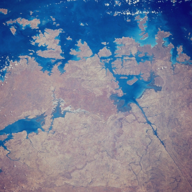 |
| STS033-079-031 Saint George Basin, Western Australia, Australia November 1989 Several of the islands that make up the Bonaparte Archipelago are visible in this view of the rugged north coast of Western Australia. Prince Regent River, the exceptionally straight dark feature (lower right quadrant) that is oriented southeast-northwest, flows into St. George Basin, the body of water which lies upper right of center almost surrounded by land. The river's linearity indicates that it is located along a major fault that extends into the Indian Ocean at Brunswick Bay (top) The body of water along the lower left side of the picture is an inlet of Doubtful Bay. |
| Images: | All Available Images Low-Resolution 339k |
|
| Mission: | STS033 |
|
| Roll - Frame: | 79 - 31 |
|
| Geographical Name: | AUSTRALIA-WA |
|
| Features: | SAINT GEORGE BASIN |
|
| Center Lat x Lon: | 15.5S x 125.0E |
|
| Film Exposure: | N | N=Normal exposure, U=Under exposed, O=Over exposed, F=out of Focus |
| Percentage of Cloud Cover-CLDP: | 5 |
|
| Camera:: | HB |
|
| Camera Tilt: | 30 | LO=Low Oblique, HO=High Oblique, NV=Near Vertical |
| Camera Focal Length: | 250 |
|
| Nadir to Photo Center Direction: | N | The direction from the nadir to the center point, N=North, S=South, E=East, W=West |
| Stereo?: | Y | Y=Yes there is an adjacent picture of the same area, N=No there isn't |
| Orbit Number: | 17 |
|
| Date: | 19891124 | YYYYMMDD |
| Time: | 015320 | GMT HHMMSS |
| Nadir Lat: | 17.6S |
Latitude of suborbital point of spacecraft |
| Nadir Lon: | 125.1E |
Longitude of suborbital point of spacecraft |
| Sun Azimuth: | 101 | Clockwise angle in degrees from north to the sun measured at the nadir point |
| Space Craft Altitude: | 220 | nautical miles |
| Sun Elevation: | 68 | Angle in degrees between the horizon and the sun, measured at the nadir point |
| Land Views: | PENINSULA, FAULT |
|
| Water Views: | RIVER, BAY |
|
| Atmosphere Views: | |
|
| Man Made Views: | |
|
| City Views: | |
|
Photo is not associated with any sequences | ||
| NASA Home Page |
JSC Home Page |
JSC Digital Image Collection |
Earth Science & Remote Sensing |
|
This service is provided by the International Space Station program and the JSC Earth Science & Remote Sensing Unit, ARES Division, Exploration Integration Science Directorate.

|