
Geographic Region: AUSTRALIA-WA
Feature: LAKE MCLEOD
|
Geographic Region: AUSTRALIA-WA Feature: LAKE MCLEOD |
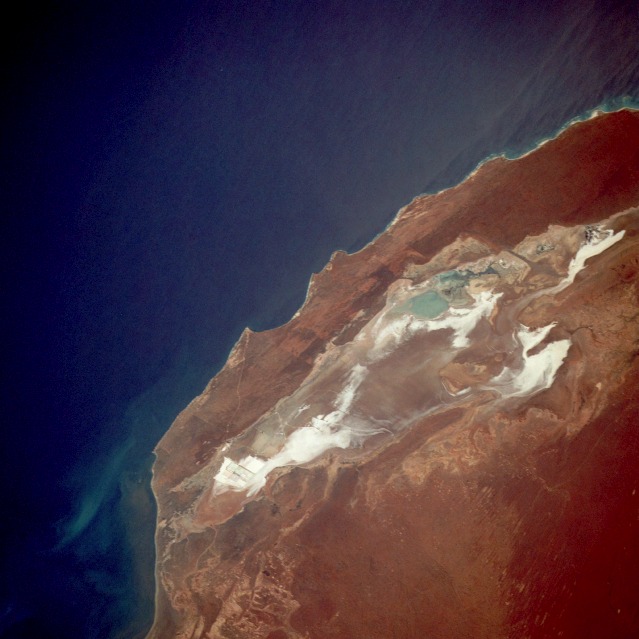 |
| STS033-079-018 Lake Macleod, Western Australia, Australia November 1989 Located north of the small coastal city of Carnarvon, estimated population 7200, Lake Macleod is the westernmost lake in Western Australia. Climatically, this part of Western Australia is greatly influenced by the north-flowing Western Australian current that brings cool water northward from Antarctica, which is not conducive to producing inland precipitation. This cool offshore current, coupled with a very flat coastal plain, contributes to the near-desert-like conditions along the coastal region as evidenced by the brown landscape around the lake and the highly reflective salt beds within the lake. The low point in the lake appears to be near the northern end where the light blues indicate some standing water. Close inspection discloses very faint lines at the southernmost end of Lake Macleod where large evaporation beds are used for the production of high-quality salt. Dirk Hartog, a Dutchman, made the first authenticated landing by a European along this coastline in 1616. Early explorers recorded phenomenal tidal ranges along this coastal area. |
| Images: | All Available Images Low-Resolution 91k |
|
| Mission: | STS033 |
|
| Roll - Frame: | 79 - 18 |
|
| Geographical Name: | AUSTRALIA-WA |
|
| Features: | LAKE MCLEOD |
|
| Center Lat x Lon: | 24S x 113.5E |
|
| Film Exposure: | N | N=Normal exposure, U=Under exposed, O=Over exposed, F=out of Focus |
| Percentage of Cloud Cover-CLDP: | 0 |
|
| Camera:: | HB |
|
| Camera Tilt: | 29 | LO=Low Oblique, HO=High Oblique, NV=Near Vertical |
| Camera Focal Length: | 250 |
|
| Nadir to Photo Center Direction: | SE | The direction from the nadir to the center point, N=North, S=South, E=East, W=West |
| Stereo?: | N | Y=Yes there is an adjacent picture of the same area, N=No there isn't |
| Orbit Number: | 17 |
|
| Date: | 19891124 | YYYYMMDD |
| Time: | 014937 | GMT HHMMSS |
| Nadir Lat: | 22.7S |
Latitude of suborbital point of spacecraft |
| Nadir Lon: | 111.7E |
Longitude of suborbital point of spacecraft |
| Sun Azimuth: | 94 | Clockwise angle in degrees from north to the sun measured at the nadir point |
| Space Craft Altitude: | 241 | nautical miles |
| Sun Elevation: | 55 | Angle in degrees between the horizon and the sun, measured at the nadir point |
| Land Views: | COAST, DESERT |
|
| Water Views: | LAKE, PLAYA |
|
| Atmosphere Views: | |
|
| Man Made Views: | MINING |
|
| City Views: | |
|
Photo is not associated with any sequences | ||
| NASA Home Page |
JSC Home Page |
JSC Digital Image Collection |
Earth Science & Remote Sensing |
|
This service is provided by the International Space Station program and the JSC Earth Science & Remote Sensing Unit, ARES Division, Exploration Integration Science Directorate.

|