
Geographic Region: PACIFIC OCEAN
Feature: CLOUDS
|
Geographic Region: PACIFIC OCEAN Feature: CLOUDS |
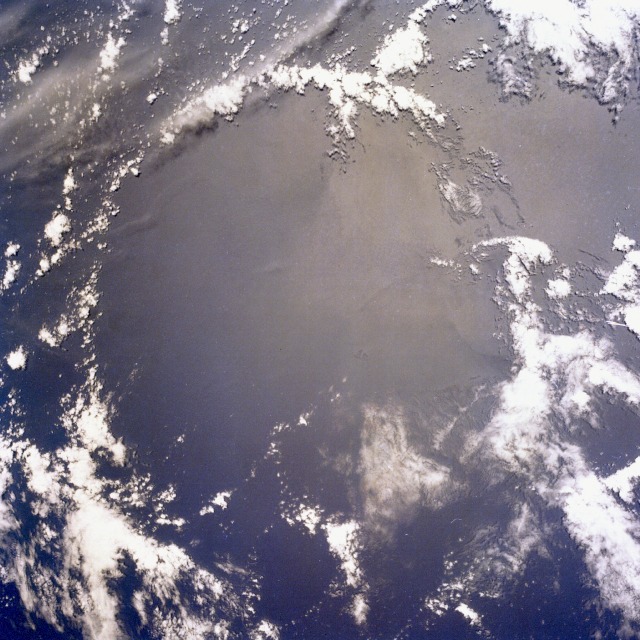 |
| STS032-097-006 Collapsed Thunderstorm, Southern Pacific Ocean January 1990 This low-oblique view shows the remains of a collapsed thunderstorm in the southern Pacific Ocean northwest of Easter Island and northeast of Henderson Island. The surrounding arc cloud marks the edge of the cold air surge which developed when the storm collapsed. Thunderstorms develop as warm, moist air rises. As the moist air rises, it turns into rain or ice droplets. As the thunderstorm reaches its mature stage, violent updrafts are noted and precipitation begins. At the onset of precipitation, strong down-drafts develop. Falling precipitation reverses rising air columns by frictional drag, and the storm eventually begins to dissipate or collapse. At times around the arc cloud of the collapsing thunderstorm, new thunderstorms may begin to form. |
| Images: | All Available Images Low-Resolution 140k |
|
| Mission: | STS032 |
|
| Roll - Frame: | 97 - 6 |
|
| Geographical Name: | PACIFIC OCEAN |
|
| Features: | CLOUDS |
|
| Center Lat x Lon: | N x E |
|
| Film Exposure: | N | N=Normal exposure, U=Under exposed, O=Over exposed, F=out of Focus |
| Percentage of Cloud Cover-CLDP: | 70 |
|
| Camera:: | HB |
|
| Camera Tilt: | LO=Low Oblique, HO=High Oblique, NV=Near Vertical |
|
| Camera Focal Length: | 100 |
|
| Nadir to Photo Center Direction: | The direction from the nadir to the center point, N=North, S=South, E=East, W=West |
|
| Stereo?: | Y | Y=Yes there is an adjacent picture of the same area, N=No there isn't |
| Orbit Number: | 101 |
|
| Date: | 19900115 | YYYYMMDD |
| Time: | 204921 | GMT HHMMSS |
| Nadir Lat: | 17.9S |
Latitude of suborbital point of spacecraft |
| Nadir Lon: | 117W |
Longitude of suborbital point of spacecraft |
| Sun Azimuth: | 253 | Clockwise angle in degrees from north to the sun measured at the nadir point |
| Space Craft Altitude: | 179 | nautical miles |
| Sun Elevation: | 76 | Angle in degrees between the horizon and the sun, measured at the nadir point |
| Land Views: | |
|
| Water Views: | OCEAN, SUNGLINT |
|
| Atmosphere Views: | THUNDERSTORM |
|
| Man Made Views: | |
|
| City Views: | |
|
Photo is not associated with any sequences | ||
| NASA Home Page |
JSC Home Page |
JSC Digital Image Collection |
Earth Science & Remote Sensing |
|
This service is provided by the International Space Station program and the JSC Earth Science & Remote Sensing Unit, ARES Division, Exploration Integration Science Directorate.

|