
Geographic Region: SAUDI ARABIA
Feature: IRRIGATED AGRICULTURE
|
Geographic Region: SAUDI ARABIA Feature: IRRIGATED AGRICULTURE |
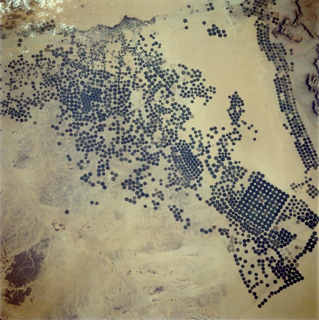 |
| STS032-096-032 Irrigated Agriculture (Center-Pivot Irrigation), Saudi Arabia January 1990 This photograph shows a location southwest of Riyadh in the Jabal Tuwayq area of Saudi Arabia. The circular features that dot the desert landscape in this near-vertical photograph are created by pivoting sprinklers, a method of irrigation whereby water from a central well is spread by a sprinkler pivoting around that well. Center-pivot irrigation is most often used in arid and semiarid regions of the world. The diameter of these circular fields can vary from several hundred feet (tens of meters) to over a mile (2 kilometers). This extensive area of center-pivot irrigation is one of four in Saudi Arabia that have been documented by recent Space Shuttle missions. The water is being extracted from subsurface reserves that infiltrated deep aquifers during geological periods when the climate was much wetter than at present. Center-pivot irrigation is not unique to Saudi Arabia, and there is danger in that there is a finite supply of "fossil" water for irrigation use. (Refer to STS-062-110-0AA for a synoptic view of a much larger area northwest of Riyadh where center-pivot irrigation is also being used for agricultural purposes.) In Saudi Arabia, center-pivot, swing-arm irrigated agriculture complexes such as the one imaged at Jabal Tuwayq (20.5N, 45.0 E) extract deep fossil water reserves to achieve food crop production self sufficiency in this desert environment. The significance of the Saudi expanded irrigated agriculture is that the depletion of this finite water resource is a short term solution to a long term need that will still exist when the water has been extracted. |
| Images: | All Available Images Low-Resolution 163k |
|
| Mission: | STS032 |
|
| Roll - Frame: | 96 - 32 |
|
| Geographical Name: | SAUDI ARABIA |
|
| Features: | IRRIGATED AGRICULTURE |
|
| Center Lat x Lon: | 20.0N x 45.0E |
|
| Film Exposure: | N | N=Normal exposure, U=Under exposed, O=Over exposed, F=out of Focus |
| Percentage of Cloud Cover-CLDP: | 5 |
|
| Camera:: | HB |
|
| Camera Tilt: | 18 | LO=Low Oblique, HO=High Oblique, NV=Near Vertical |
| Camera Focal Length: | 250 |
|
| Nadir to Photo Center Direction: | E | The direction from the nadir to the center point, N=North, S=South, E=East, W=West |
| Stereo?: | Y | Y=Yes there is an adjacent picture of the same area, N=No there isn't |
| Orbit Number: | 91 |
|
| Date: | 19900115 | YYYYMMDD |
| Time: | 052019 | GMT HHMMSS |
| Nadir Lat: | 19.6N |
Latitude of suborbital point of spacecraft |
| Nadir Lon: | 44.1E |
Longitude of suborbital point of spacecraft |
| Sun Azimuth: | 122 | Clockwise angle in degrees from north to the sun measured at the nadir point |
| Space Craft Altitude: | 177 | nautical miles |
| Sun Elevation: | 20 | Angle in degrees between the horizon and the sun, measured at the nadir point |
| Land Views: | DESERT, PLATEAU |
|
| Water Views: | |
|
| Atmosphere Views: | |
|
| Man Made Views: | AGRICULTURE |
|
| City Views: | |
|
Associated Photos in Sequence:  Photo #: STS032-96-32 ** Currently displayed photo ** Photo #: STS032-96-32 ** Currently displayed photo ** Description: SAUDI ARABIA, NAFUD-1990; CHANGING DESERT PIVOT IRRIGATION PATTERNS Sequence ID: 8A  Photo #: STS060-97-38 Photo #: STS060-97-38Description: SAUDI ARABIA, NAFUD-1/94; CHANGING DESERT PIVOT IRRIGATION PATTERNS Sequence ID: 8B  Photo #: STS062-110-AA Photo #: STS062-110-AADescription: SAUDI ARABIA, NAFUD-3/94; CHANGING DESERT PIVOT IRRIGATION PATTERNS Sequence ID: 8C | ||
| NASA Home Page |
JSC Home Page |
JSC Digital Image Collection |
Earth Science & Remote Sensing |
|
This service is provided by the International Space Station program and the JSC Earth Science & Remote Sensing Unit, ARES Division, Exploration Integration Science Directorate.

|