Geographic Region: INDIA
Feature: KRISHNA R/DELTA, COAST
|
Geographic Region: INDIA Feature: KRISHNA R/DELTA, COAST |
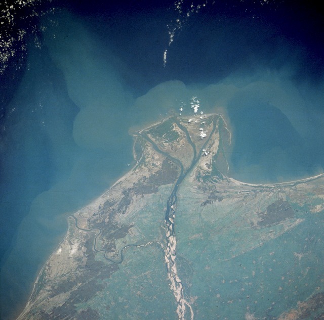 |
| STS032-72-61 Krishna River, India The Krishna River flows eastward across the Deccan Plateau of southern India until it empties through four major distributaries into the Bay of Bengal. The river, with its headwaters in the eastern slopes of the Western Ghats, flows eastward for approximately 800 miles (1300 kilometers) until it bends southward for the last 50 miles (80 kilometers). The Krishna River delta is typical of the wider deltas along the southeast coast of India (also known as the Coromandel Coast). The braided stream channels, broad floodplain, and extensive sandbars suggest that this part of the Krishna River flows through relatively flat terrain and carries substantial amounts of sediment, especially during the monsoon season. The outline of the city of Guntur and nearby, smaller rice-producing towns are visible near the northwest edge of the photograph. |
| Images: | All Available Images Low-Resolution 100k |
|
| Mission: | STS032 |
|
| Roll - Frame: | 72 - 61 |
|
| Geographical Name: | INDIA |
|
| Features: | KRISHNA R/DELTA, COAST |
|
| Center Lat x Lon: | 16.0N x 81.0E |
|
| Film Exposure: | N | N=Normal exposure, U=Under exposed, O=Over exposed, F=out of Focus |
| Percentage of Cloud Cover-CLDP: | 10 |
|
| Camera:: | HB |
|
| Camera Tilt: | 31 | LO=Low Oblique, HO=High Oblique, NV=Near Vertical |
| Camera Focal Length: | 250 |
|
| Nadir to Photo Center Direction: | N | The direction from the nadir to the center point, N=North, S=South, E=East, W=West |
| Stereo?: | N | Y=Yes there is an adjacent picture of the same area, N=No there isn't |
| Orbit Number: | 28 |
|
| Date: | 19900111 | YYYYMMDD |
| Time: | 055141 | GMT HHMMSS |
| Nadir Lat: | 14.4N |
Latitude of suborbital point of spacecraft |
| Nadir Lon: | 81.8E |
Longitude of suborbital point of spacecraft |
| Sun Azimuth: | 161 | Clockwise angle in degrees from north to the sun measured at the nadir point |
| Space Craft Altitude: | 175 | nautical miles |
| Sun Elevation: | 51 | Angle in degrees between the horizon and the sun, measured at the nadir point |
| Land Views: | COAST, PLAIN |
|
| Water Views: | DELTA, RIVER, BAY, SEDIMENT |
|
| Atmosphere Views: | |
|
| Man Made Views: | AGRICULTURE |
|
| City Views: | |
|
Photo is not associated with any sequences | ||
| NASA Home Page |
JSC Home Page |
JSC Digital Image Collection |
Earth Science & Remote Sensing |
|
This service is provided by the International Space Station program and the JSC Earth Science & Remote Sensing Unit, ARES Division, Exploration Integration Science Directorate.

|