
Geographic Region: AUSTRALIA-WA
Feature: HAMERSLEY RANGE
|
Geographic Region: AUSTRALIA-WA Feature: HAMERSLEY RANGE |
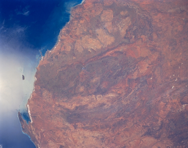 |
| STS031-152-0DL Hamersley Range, Western Australia, Australia April 1990 The entire Hamersley Range is visible in this synoptic view of northwestern Australia. This folded range of mountains (seen as a darker green-brown area in the center of the image) trends generally east-west and is bounded north and south by two river valleys (somewhat linear, lighter colored areas). The Fortescue River is the relatively narrow valley north of the mountains and the broader valley south of the mountains is the Ashburton River. The Hamersley Range has peaks that reach 4000 feet (1200 meters) above sea level. A series of curving, lower mountains, that parallel the Hamersley can also be seen south of the Ashburton River. The Hamersley area is a major source of iron formations and the area north of the Hamersley contain some of the oldest rocks in the world, dating back 3.5 billion years. The lighter color areas north of the Hamersley, known as the Pilbara District, contains huge granite plutons. The small bay (lower left) in the corner of the image is Exmouth Gulf. The oval shaped basin of the sedimentary rocks of the Hammersley Range, northern Western Australia (23.0S, 119.0E) dominates the center of this near nadir view. The Fortescue River is the remarkably straight, fault controlled feature bordering the Hammersley on the north. Sand dunes are the main surface features in the northeast and southwest. Many dry lakebeds can be seen to the east as light grey colored patches along the watercourses. |
| Images: | All Available Images Low-Resolution 247k |
|
| Mission: | STS031 |
|
| Roll - Frame: | 152 - DL |
|
| Geographical Name: | AUSTRALIA-WA |
|
| Features: | HAMERSLEY RANGE |
|
| Center Lat x Lon: | 23S x 118.0E |
|
| Film Exposure: | N | N=Normal exposure, U=Under exposed, O=Over exposed, F=out of Focus |
| Percentage of Cloud Cover-CLDP: | 0 |
|
| Camera:: | LH |
|
| Camera Tilt: | LO | LO=Low Oblique, HO=High Oblique, NV=Near Vertical |
| Camera Focal Length: | 90 |
|
| Nadir to Photo Center Direction: | The direction from the nadir to the center point, N=North, S=South, E=East, W=West |
|
| Stereo?: | Y | Y=Yes there is an adjacent picture of the same area, N=No there isn't |
| Orbit Number: | |
|
| Date: | 199004__ | YYYYMMDD |
| Time: | GMT HHMMSS |
|
| Nadir Lat: | N |
Latitude of suborbital point of spacecraft |
| Nadir Lon: | E |
Longitude of suborbital point of spacecraft |
| Sun Azimuth: | Clockwise angle in degrees from north to the sun measured at the nadir point |
|
| Space Craft Altitude: | nautical miles |
|
| Sun Elevation: | Angle in degrees between the horizon and the sun, measured at the nadir point |
|
| Land Views: | MOUNTAIN |
|
| Water Views: | RIVER, BAY |
|
| Atmosphere Views: | |
|
| Man Made Views: | |
|
| City Views: | |
|
Photo is not associated with any sequences | ||
| NASA Home Page |
JSC Home Page |
JSC Digital Image Collection |
Earth Science & Remote Sensing |
|
This service is provided by the International Space Station program and the JSC Earth Science & Remote Sensing Unit, ARES Division, Exploration Integration Science Directorate.

|