Geographic Region: MAURITANIA
Feature: BAIE DE LEVERIER
|
Geographic Region: MAURITANIA Feature: BAIE DE LEVERIER |
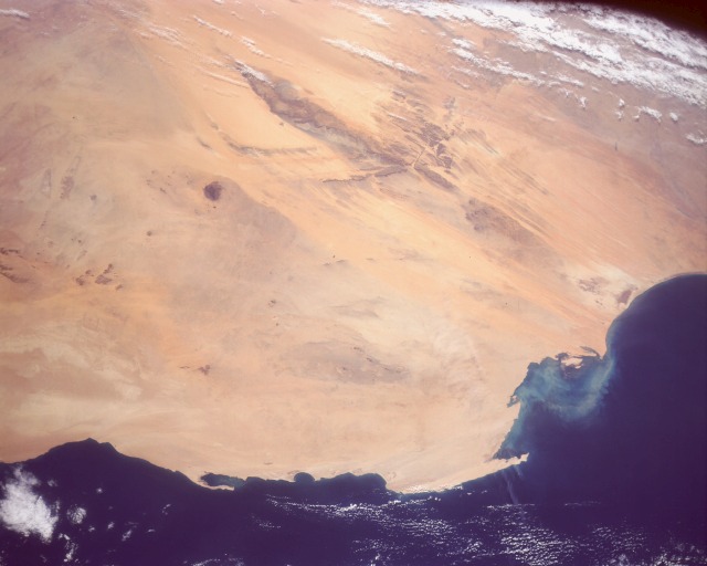 |
| STS031-151-16 Linear Sand Dunes, Mauritania April 1990 The western end of the great Sahara Desert is captured in this southeast-looking, low oblique photograph of desert and coastal areas of Mauritania. This region of west Africa is a major source of eolian sand that is transported across the Atlantic Ocean to North America. Other photographs taken during Space Shuttle flights have charted the distance and areal extent that these west African dust palls travel. The yellow and orange areas are sand dunes and sand sheets, and the darker areas are bedrock outcrops. The entire area is overlain by Quaternary deposits. Pleistocene paleo-dune fields (A Zefal and Amoukrouz) are along the southern coast. The view covers an area roughly 700 by 800 km. The major area of northeast-southwest-trending bedrock produces a downwind "wind shadow" effect on the landscape that extends to the coast. The northern grayish areas with little or no sand are rock and gravel desert plains. The peninsula of Cape Blanc protrudes into Levrier Bay. |
| Images: | All Available Images Low-Resolution 68k |
|
| Mission: | STS031 |
|
| Roll - Frame: | 151 - 16 |
|
| Geographical Name: | MAURITANIA |
|
| Features: | BAIE DE LEVERIER |
|
| Center Lat x Lon: | 21.5N x 14.5W |
|
| Film Exposure: | N | N=Normal exposure, U=Under exposed, O=Over exposed, F=out of Focus |
| Percentage of Cloud Cover-CLDP: | 5 |
|
| Camera:: | LH |
|
| Camera Tilt: | HO | LO=Low Oblique, HO=High Oblique, NV=Near Vertical |
| Camera Focal Length: | 90 |
|
| Nadir to Photo Center Direction: | SE | The direction from the nadir to the center point, N=North, S=South, E=East, W=West |
| Stereo?: | N | Y=Yes there is an adjacent picture of the same area, N=No there isn't |
| Orbit Number: | 29 |
|
| Date: | 19900426 | YYYYMMDD |
| Time: | 095627 | GMT HHMMSS |
| Nadir Lat: | 23.3N |
Latitude of suborbital point of spacecraft |
| Nadir Lon: | 16.6W |
Longitude of suborbital point of spacecraft |
| Sun Azimuth: | 93 | Clockwise angle in degrees from north to the sun measured at the nadir point |
| Space Craft Altitude: | 334 | nautical miles |
| Sun Elevation: | 44 | Angle in degrees between the horizon and the sun, measured at the nadir point |
| Land Views: | DESERT, DUNE |
|
| Water Views: | |
|
| Atmosphere Views: | |
|
| Man Made Views: | |
|
| City Views: | |
|
Photo is not associated with any sequences | ||
| NASA Home Page |
JSC Home Page |
JSC Digital Image Collection |
Earth Science & Remote Sensing |
|
This service is provided by the International Space Station program and the JSC Earth Science & Remote Sensing Unit, ARES Division, Exploration Integration Science Directorate.

|