
Geographic Region: USA-LOUISIANA
Feature: NEW ORLEANS, MS. RIVER
|
Geographic Region: USA-LOUISIANA Feature: NEW ORLEANS, MS. RIVER |
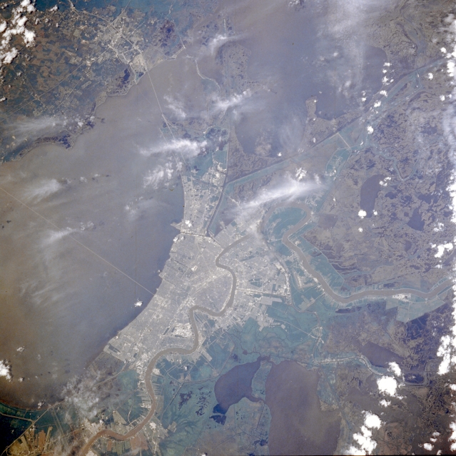 |
| STS030-076-041 New Orleans, Louisiana, U.S.A. May 1989 Featured in this photograph are metropolitan New Orleans; the verdant terrain immediately outside the urban area showing river alluvium and levees; and the dark, rural landscape surrounding New Orleans with numerous lakes interspersed throughout the swampy wetlands that are prevalent in this part of the Mississippi River delta. Apparent are large Salvador Lake south of New Orleans; most of the 24-mile (39-kilometer) causeway that connects New Orleans with the north shore of Lake Pontchartrain; and the shorter causeway that connects the eastern end of New Orleans to Slidell on the north shore of the lake. The canal system along the east side of New Orleans is part of the Intracoastal Waterway. The meandering, sediment-laden Mississippi River illustrates why New Orleans is nicknamed the Crescent City. As one of the best ever views of the city of New Orleans, LA (30.0N, 90.0W) from space, this image allows the study of the city and the region in minute detail. Major city street and highway patterns can easily be traced. Even the Superdome near the old French Quarter can be seen as a large round white circle near the middle of the photo. The French Napoleonic Code land distribution system of long narrow fields fronting the river is also evident. |
| Images: | All Available Images Low-Resolution 327k |
|
| Mission: | STS030 |
|
| Roll - Frame: | 76 - 41 |
|
| Geographical Name: | USA-LOUISIANA |
|
| Features: | NEW ORLEANS, MS. RIVER |
|
| Center Lat x Lon: | 30.0N x 90W |
|
| Film Exposure: | N | N=Normal exposure, U=Under exposed, O=Over exposed, F=out of Focus |
| Percentage of Cloud Cover-CLDP: | 15 |
|
| Camera:: | HB |
|
| Camera Tilt: | 23 | LO=Low Oblique, HO=High Oblique, NV=Near Vertical |
| Camera Focal Length: | 250 |
|
| Nadir to Photo Center Direction: | N | The direction from the nadir to the center point, N=North, S=South, E=East, W=West |
| Stereo?: | N | Y=Yes there is an adjacent picture of the same area, N=No there isn't |
| Orbit Number: | 17 |
|
| Date: | 19890505 | YYYYMMDD |
| Time: | 190025 | GMT HHMMSS |
| Nadir Lat: | 28.9N |
Latitude of suborbital point of spacecraft |
| Nadir Lon: | 90.5W |
Longitude of suborbital point of spacecraft |
| Sun Azimuth: | 232 | Clockwise angle in degrees from north to the sun measured at the nadir point |
| Space Craft Altitude: | 173 | nautical miles |
| Sun Elevation: | 71 | Angle in degrees between the horizon and the sun, measured at the nadir point |
| Land Views: | |
|
| Water Views: | LAKE, CHANNEL, SWAMP, DELTA, RIVER |
|
| Atmosphere Views: | |
|
| Man Made Views: | URBAN AREA, HIGHWAY |
|
| City Views: | |
|
Photo is not associated with any sequences | ||
| NASA Home Page |
JSC Home Page |
JSC Digital Image Collection |
Earth Science & Remote Sensing |
|
This service is provided by the International Space Station program and the JSC Earth Science & Remote Sensing Unit, ARES Division, Exploration Integration Science Directorate.

|