
Geographic Region: MYANMAR (BURMA)
Feature: CHINDWIN/IRRAWADDY RIV.
|
Geographic Region: MYANMAR (BURMA) Feature: CHINDWIN/IRRAWADDY RIV. |
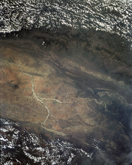 |
| STS030-151-062 Irrawaddy River, Mandalay, Burma May 1989 The generally south flowing Irrawaddy River can be seen in this south-looking view. The Irrawaddy, the major river of Burma (Myanmar) is 1300 miles (2039 km) long. Rising in the mountains of northern Burma, the Irrawaddy River is surrounded on three sides, north, east, and west, by mountains that gives the valley the appearance of a giant horseshoe. The Irrawaddy River Valley, estimated by geologists to be nearly 45 million years old, is home to a majority of Burma's population. The valley is used extensively agricultural. Just to the left of the center of the image, the Chindwin River joins the Irrawaddy at the port city of Myingyan. The Chindwin River rises in the Kumon Range in northern Burma and is the chief tributary of the Irrawaddy. Mandalay is a trade center with railroad and steamer connections, and is located where the Irrawaddy makes a severe course change (lower left quadrant). It is the center for Burmese Buddhism. Clouds cover the mountain ranges to the east (bottom) and west (top) of the broad valley. |
| Images: | All Available Images Low-Resolution 335k |
|
| Mission: | STS030 |
|
| Roll - Frame: | 151 - 62 |
|
| Geographical Name: | MYANMAR (BURMA) |
|
| Features: | CHINDWIN/IRRAWADDY RIV. |
|
| Center Lat x Lon: | 22.0N x 94.5E |
|
| Film Exposure: | N | N=Normal exposure, U=Under exposed, O=Over exposed, F=out of Focus |
| Percentage of Cloud Cover-CLDP: | 40 |
|
| Camera:: | LH |
|
| Camera Tilt: | 11 | LO=Low Oblique, HO=High Oblique, NV=Near Vertical |
| Camera Focal Length: | 90 |
|
| Nadir to Photo Center Direction: | NE | The direction from the nadir to the center point, N=North, S=South, E=East, W=West |
| Stereo?: | Y | Y=Yes there is an adjacent picture of the same area, N=No there isn't |
| Orbit Number: | 23 |
|
| Date: | 19890506 | YYYYMMDD |
| Time: | 035510 | GMT HHMMSS |
| Nadir Lat: | 21.7N |
Latitude of suborbital point of spacecraft |
| Nadir Lon: | 94.0E |
Longitude of suborbital point of spacecraft |
| Sun Azimuth: | 97 | Clockwise angle in degrees from north to the sun measured at the nadir point |
| Space Craft Altitude: | 177 | nautical miles |
| Sun Elevation: | 64 | Angle in degrees between the horizon and the sun, measured at the nadir point |
| Land Views: | PLAIN, MOUNTAIN |
|
| Water Views: | RIVER |
|
| Atmosphere Views: | |
|
| Man Made Views: | |
|
| City Views: | |
|
Photo is not associated with any sequences | ||
| NASA Home Page |
JSC Home Page |
JSC Digital Image Collection |
Earth Science & Remote Sensing |
|
This service is provided by the International Space Station program and the JSC Earth Science & Remote Sensing Unit, ARES Division, Exploration Integration Science Directorate.

|