Geographic Region: TANZANIA
Feature: LAKE NATRON
|
Geographic Region: TANZANIA Feature: LAKE NATRON |
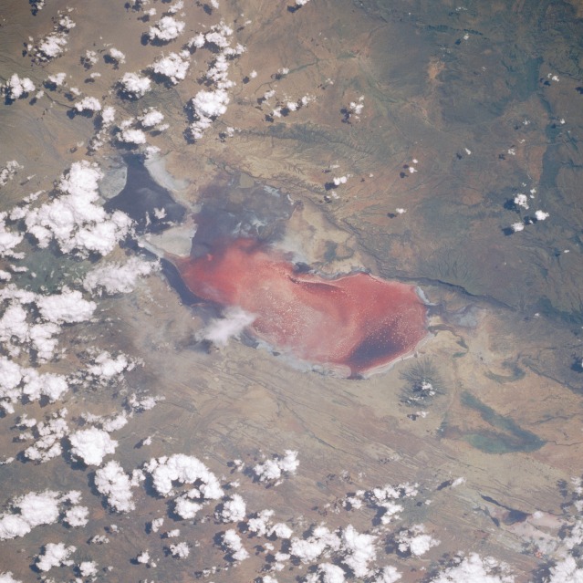 |
| STS029-092-038 Lake Natron, Tanzania March 1989 Lake Natron (pink color results from the pigmented microorganisms on top of the salt crust), approximately 35 miles (56 kilometers) long and 15 miles (24 kilometers) wide, has its northern end on the Tanzania-Kenya border; the summit of the small volcano, 5130 feet (1560 meters) above sea level at the northern end of the lake, is in Kenya. The north-south-trending lines on either side of Lake Natron help to establish the width of the Rift Valley at this point as approximately 20 miles (32 kilometers). Although this part of Africa has a humid, equatorial classification, this area has a definite dry winter season and varying rainfall amounts averaging approximately 40 inches (100 centimeters) annually. Lake Natron and its flamingo population are very sensitive to rainfall amounts-both suffer during drought. (Refer to photograph STS-41B-046-2955, taken 5 years earlier, which shows differences in the extent of the salt crust.) |
| Images: | All Available Images Low-Resolution 129k |
|
| Mission: | STS029 |
|
| Roll - Frame: | 92 - 38 |
|
| Geographical Name: | TANZANIA |
|
| Features: | LAKE NATRON |
|
| Center Lat x Lon: | 2.5S x 36.0E |
|
| Film Exposure: | N | N=Normal exposure, U=Under exposed, O=Over exposed, F=out of Focus |
| Percentage of Cloud Cover-CLDP: | 40 |
|
| Camera:: | HB |
|
| Camera Tilt: | 33 | LO=Low Oblique, HO=High Oblique, NV=Near Vertical |
| Camera Focal Length: | 250 |
|
| Nadir to Photo Center Direction: | E | The direction from the nadir to the center point, N=North, S=South, E=East, W=West |
| Stereo?: | N | Y=Yes there is an adjacent picture of the same area, N=No there isn't |
| Orbit Number: | 31 |
|
| Date: | 19890315 | YYYYMMDD |
| Time: | 124509 | GMT HHMMSS |
| Nadir Lat: | 3S |
Latitude of suborbital point of spacecraft |
| Nadir Lon: | 34.3E |
Longitude of suborbital point of spacecraft |
| Sun Azimuth: | 270 | Clockwise angle in degrees from north to the sun measured at the nadir point |
| Space Craft Altitude: | 162 | nautical miles |
| Sun Elevation: | 46 | Angle in degrees between the horizon and the sun, measured at the nadir point |
| Land Views: | BASIN, VALLEY, FAULT, ESCARPMENT, HILL, VOLCANO |
|
| Water Views: | LAKE |
|
| Atmosphere Views: | |
|
| Man Made Views: | |
|
| City Views: | |
|
Photo is not associated with any sequences | ||
| NASA Home Page |
JSC Home Page |
JSC Digital Image Collection |
Earth Science & Remote Sensing |
|
This service is provided by the International Space Station program and the JSC Earth Science & Remote Sensing Unit, ARES Division, Exploration Integration Science Directorate.

|