
Geographic Region: BAHAMAS
Feature: TONGUE OF THE OCEAN
|
Geographic Region: BAHAMAS Feature: TONGUE OF THE OCEAN |
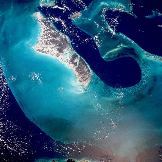 |
| STS029-90-9 West Bank of Andros Island and Tongue of the Ocean The dark blue area, aptly named "Tongue of the Ocean", is characterized by water depths as great as 3000 meters (almost 2 miles). The Atlantic Ocean just east of Eleuthera Island is nearly nearly 5000 meters deep. By comparison, the waters of the Bahama Platform are less than 15 meters deep. They are warm and become extremely salty due to evaporation and limited circulation from the open ocean. Crystals of aragonite, a calcium carbonate mineral derived from the shells of single celled marine organisms, and direct precipitation, form into oolites (small spherical grains of limestone) as the tidal currents swirl back and forth. Lithification of the carbonate sands produces an oolite limestone. Although the water is warm and clear, corals do not live in the shallows, probably because of the salt content. Though chemically very similar, the rocks resulting from this process have a quite different origin from those formed from coral reefs. |
| Images: | All Available Images Low-Resolution 134k |
|
| Mission: | STS029 |
|
| Roll - Frame: | 90 - 9 |
|
| Geographical Name: | BAHAMAS |
|
| Features: | TONGUE OF THE OCEAN |
|
| Center Lat x Lon: | 24.0N x 78W |
|
| Film Exposure: | N | N=Normal exposure, U=Under exposed, O=Over exposed, F=out of Focus |
| Percentage of Cloud Cover-CLDP: | 20 |
|
| Camera:: | HB |
|
| Camera Tilt: | 18 | LO=Low Oblique, HO=High Oblique, NV=Near Vertical |
| Camera Focal Length: | 50 |
|
| Nadir to Photo Center Direction: | N | The direction from the nadir to the center point, N=North, S=South, E=East, W=West |
| Stereo?: | Y | Y=Yes there is an adjacent picture of the same area, N=No there isn't |
| Orbit Number: | 18 |
|
| Date: | 19890314 | YYYYMMDD |
| Time: | 165046 | GMT HHMMSS |
| Nadir Lat: | 23.2N |
Latitude of suborbital point of spacecraft |
| Nadir Lon: | 77.6W |
Longitude of suborbital point of spacecraft |
| Sun Azimuth: | 163 | Clockwise angle in degrees from north to the sun measured at the nadir point |
| Space Craft Altitude: | 168 | nautical miles |
| Sun Elevation: | 63 | Angle in degrees between the horizon and the sun, measured at the nadir point |
| Land Views: | ISLAND |
|
| Water Views: | CHANNEL, REEF |
|
| Atmosphere Views: | |
|
| Man Made Views: | |
|
| City Views: | |
|
Photo is not associated with any sequences | ||
| NASA Home Page |
JSC Home Page |
JSC Digital Image Collection |
Earth Science & Remote Sensing |
|
This service is provided by the International Space Station program and the JSC Earth Science & Remote Sensing Unit, ARES Division, Exploration Integration Science Directorate.

|