
Geographic Region: CAMEROON
Feature: TIBATI RESERVOIR
|
Geographic Region: CAMEROON Feature: TIBATI RESERVOIR |
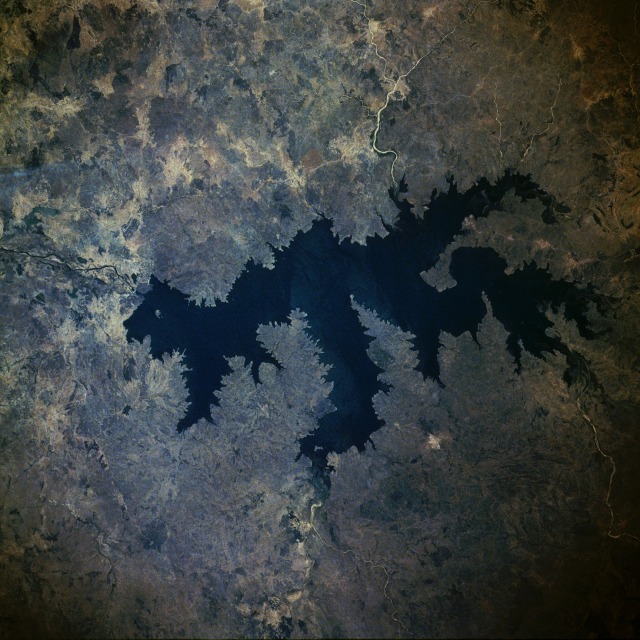 |
| STS029-085-039 Lagdo Reservoir, Cameroon March 1989 Lagdo Reservoir is one of several recently constructed reservoirs in northern Cameroon. The reservoir is located on the Bénoué River between the city of Garoua to the northwest and Bénoué National Park to the south. The Bénoué flows generally westward into east-central Nigeria's Benue River, a major tributary of the Niger River. Like many other reservoirs that have been constructed in semiarid, steppe grasslands, Lagdo provides water for irrigation and flood control, but a substantial quantity of water is lost through evaporation. The dam is located at the northwest corner of the reservoir. Siltation--always a problem in this type of fragile environment--is intensified by many feeder streams on the periphery of the reservoir. |
| Images: | All Available Images Low-Resolution 142k |
|
| Mission: | STS029 |
|
| Roll - Frame: | 85 - 39 |
|
| Geographical Name: | CAMEROON |
|
| Features: | TIBATI RESERVOIR |
|
| Center Lat x Lon: | 6.5N x 13.0E |
|
| Film Exposure: | N | N=Normal exposure, U=Under exposed, O=Over exposed, F=out of Focus |
| Percentage of Cloud Cover-CLDP: | 0 |
|
| Camera:: | HB |
|
| Camera Tilt: | 45 | LO=Low Oblique, HO=High Oblique, NV=Near Vertical |
| Camera Focal Length: | 250 |
|
| Nadir to Photo Center Direction: | SW | The direction from the nadir to the center point, N=North, S=South, E=East, W=West |
| Stereo?: | N | Y=Yes there is an adjacent picture of the same area, N=No there isn't |
| Orbit Number: | 62 |
|
| Date: | 19890317 | YYYYMMDD |
| Time: | 113026 | GMT HHMMSS |
| Nadir Lat: | 8.4N |
Latitude of suborbital point of spacecraft |
| Nadir Lon: | 15.1E |
Longitude of suborbital point of spacecraft |
| Sun Azimuth: | 210 | Clockwise angle in degrees from north to the sun measured at the nadir point |
| Space Craft Altitude: | 167 | nautical miles |
| Sun Elevation: | 78 | Angle in degrees between the horizon and the sun, measured at the nadir point |
| Land Views: | HILL |
|
| Water Views: | RIVER, RESERVOIR |
|
| Atmosphere Views: | |
|
| Man Made Views: | DAM |
|
| City Views: | |
|
Photo is not associated with any sequences | ||
| NASA Home Page |
JSC Home Page |
JSC Digital Image Collection |
Earth Science & Remote Sensing |
|
This service is provided by the International Space Station program and the JSC Earth Science & Remote Sensing Unit, ARES Division, Exploration Integration Science Directorate.

|