
Geographic Region: USA-TEXAS
Feature: HOUSTON, SHIP CHANNEL
|
Geographic Region: USA-TEXAS Feature: HOUSTON, SHIP CHANNEL |
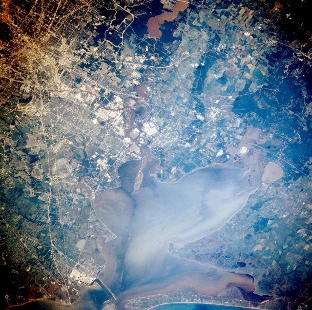 |
| STS028-098-037 Houston and Galveston Bay, Texas, U.S.A. August 1989 Houston, located on the coastal plain of southeast Texas, is known as a leading industrial and manufacturing center and ranks as one of the top three port facilities in the United States. Large industrial processing plants along the east and southeast sides of downtown are shown as highly reflective areas, primarily along the Houston Ship Channel and as far south as Texas City (bottom left corner). Oceangoing ships from the Gulf of Mexico have access to the port of Houston through Galveston Bay, showing a complex pattern of surface currents and turbid plumes, and the Houston Ship Channel, an eastern extension of Buffalo Bayou that winds through downtown Houston. North of the city is muddy Lake Houston, part of the San Jacinto River system that empties into the eastern end of the Houston Ship Channel near the northwest corner of Galveston Bay. The elongated island at this intersection is the result of dumping dredged materials from the Houston Ship Channel. To the east, the Trinity River with its swampy, lake-filled estuary (including oval Lake Anahuac) flows into Trinity Bay, which makes up the northeast segment of Galveston Bay. The extensive sediment patterns in Trinity Bay and Galveston Bay probably resulted from a recent rainstorm. |
| Images: | All Available Images Low-Resolution 421k |
|
| Mission: | STS028 |
|
| Roll - Frame: | 98 - 37 |
|
| Geographical Name: | USA-TEXAS |
|
| Features: | HOUSTON, SHIP CHANNEL |
|
| Center Lat x Lon: | 29.5N x 95W |
|
| Film Exposure: | N | N=Normal exposure, U=Under exposed, O=Over exposed, F=out of Focus |
| Percentage of Cloud Cover-CLDP: | 0 |
|
| Camera:: | HB |
|
| Camera Tilt: | 27 | LO=Low Oblique, HO=High Oblique, NV=Near Vertical |
| Camera Focal Length: | 250 |
|
| Nadir to Photo Center Direction: | SE | The direction from the nadir to the center point, N=North, S=South, E=East, W=West |
| Stereo?: | Y | Y=Yes there is an adjacent picture of the same area, N=No there isn't |
| Orbit Number: | 23 |
|
| Date: | 19890809 | YYYYMMDD |
| Time: | 222042 | GMT HHMMSS |
| Nadir Lat: | 30.5N |
Latitude of suborbital point of spacecraft |
| Nadir Lon: | 96W |
Longitude of suborbital point of spacecraft |
| Sun Azimuth: | 268 | Clockwise angle in degrees from north to the sun measured at the nadir point |
| Space Craft Altitude: | 164 | nautical miles |
| Sun Elevation: | 35 | Angle in degrees between the horizon and the sun, measured at the nadir point |
| Land Views: | PLAIN |
|
| Water Views: | BAY, CHANNEL, ESTUARY |
|
| Atmosphere Views: | |
|
| Man Made Views: | HIGHWAY, AIRPORT |
|
| City Views: | |
|
Photo is not associated with any sequences | ||
| NASA Home Page |
JSC Home Page |
JSC Digital Image Collection |
Earth Science & Remote Sensing |
|
This service is provided by the International Space Station program and the JSC Earth Science & Remote Sensing Unit, ARES Division, Exploration Integration Science Directorate.

|