
Geographic Region: USA-TEXAS
Feature: BELTON, TEMPLE, LITTLE R
|
Geographic Region: USA-TEXAS Feature: BELTON, TEMPLE, LITTLE R |
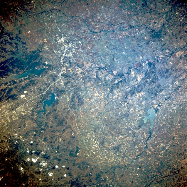 |
| STS028-098-034 Temple, Texas, U.S.A. August 1989 Thin, linear Interstate Highway 35 (top to bottom) roughly shows the location of a dramatic geologic transition zone through this section of central Texas. West of this highway that generally parallels the Balcones escarpment, the landscape is one of uplifted limestone plateaus; east of the highway, the land becomes the grassy plains of the Black Prairie with numerous tree-lined tributaries flowing toward the Brazos River (not shown). East-west-aligned U.S. Highway 190 lies between Belton Lake (north) and Stillhouse Hollow Lake (south) and merges with Interstate Highway 35 at Belton. Northeast and southeast of this junction are Temple and Lake Granger, respectively. |
| Images: | All Available Images Low-Resolution 434k |
|
| Mission: | STS028 |
|
| Roll - Frame: | 98 - 34 |
|
| Geographical Name: | USA-TEXAS |
|
| Features: | BELTON, TEMPLE, LITTLE R |
|
| Center Lat x Lon: | 31.0N x 97.5W |
|
| Film Exposure: | N | N=Normal exposure, U=Under exposed, O=Over exposed, F=out of Focus |
| Percentage of Cloud Cover-CLDP: | 5 |
|
| Camera:: | HB |
|
| Camera Tilt: | 19 | LO=Low Oblique, HO=High Oblique, NV=Near Vertical |
| Camera Focal Length: | 250 |
|
| Nadir to Photo Center Direction: | S | The direction from the nadir to the center point, N=North, S=South, E=East, W=West |
| Stereo?: | N | Y=Yes there is an adjacent picture of the same area, N=No there isn't |
| Orbit Number: | 23 |
|
| Date: | 19890809 | YYYYMMDD |
| Time: | 222015 | GMT HHMMSS |
| Nadir Lat: | 31.9N |
Latitude of suborbital point of spacecraft |
| Nadir Lon: | 97.2W |
Longitude of suborbital point of spacecraft |
| Sun Azimuth: | 266 | Clockwise angle in degrees from north to the sun measured at the nadir point |
| Space Craft Altitude: | 164 | nautical miles |
| Sun Elevation: | 36 | Angle in degrees between the horizon and the sun, measured at the nadir point |
| Land Views: | RANGE, PLATEAU |
|
| Water Views: | RESERVOIR, RIVER |
|
| Atmosphere Views: | |
|
| Man Made Views: | URBAN AREA, HIGHWAY |
|
| City Views: | |
|
Photo is not associated with any sequences | ||
| NASA Home Page |
JSC Home Page |
JSC Digital Image Collection |
Earth Science & Remote Sensing |
|
This service is provided by the International Space Station program and the JSC Earth Science & Remote Sensing Unit, ARES Division, Exploration Integration Science Directorate.

|