Geographic Region: USA-ALASKA
Feature: MALASPINA GL,YAKUTAT BAY
|
Geographic Region: USA-ALASKA Feature: MALASPINA GL,YAKUTAT BAY |
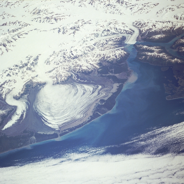 |
| STS028-097-081 Malaspina Glacier, Alaska, U.S.A. August 1989 Malaspina Glacier can be seen just left of the center of this northeast-looking, low-oblique photograph. Located in southern Alaska on the shore of the Gulf of Alaska, Malaspina Glacier is a classic example of a piedmont glacier lying at the foot of a mountain range--in this case, the Saint Elias Mountains (just north of the glacier). The glacier covers an area of 1500 square miles (3900 square kilometers) on the coastal plain, is nearly 60 miles (97 kilometers) long, and is more than 1000 feet (300 meters) thick. The Seward Ice Field is the principal source of ice for the glacier. The glacier moves in surges that push earlier-formed moraines outward into expanding concentric patterns, which you can see along the flanks of the ice mass. To the northwest of Malaspina Glacier is the curved and pointed Agassiz Glacier, which is also fed by the Seward Ice Field. To the northeast of Malaspina Glacier, located at the head of Yakutat Bay, is the Hubbard Glacier, which surged in 1989, blocking the entrance to Russell Fiord and temporarily trapping a large number of marine animals. |
| Images: | All Available Images Low-Resolution 328k |
|
| Mission: | STS028 |
|
| Roll - Frame: | 97 - 81 |
|
| Geographical Name: | USA-ALASKA |
|
| Features: | MALASPINA GL,YAKUTAT BAY |
|
| Center Lat x Lon: | 60.0N x 140W |
|
| Film Exposure: | N | N=Normal exposure, U=Under exposed, O=Over exposed, F=out of Focus |
| Percentage of Cloud Cover-CLDP: | 25 |
|
| Camera:: | HB |
|
| Camera Tilt: | LO | LO=Low Oblique, HO=High Oblique, NV=Near Vertical |
| Camera Focal Length: | 250 |
|
| Nadir to Photo Center Direction: | NE | The direction from the nadir to the center point, N=North, S=South, E=East, W=West |
| Stereo?: | Y | Y=Yes there is an adjacent picture of the same area, N=No there isn't |
| Orbit Number: | 38 |
|
| Date: | 19890810 | YYYYMMDD |
| Time: | 204525 | GMT HHMMSS |
| Nadir Lat: | 57.1N |
Latitude of suborbital point of spacecraft |
| Nadir Lon: | 143.3W |
Longitude of suborbital point of spacecraft |
| Sun Azimuth: | 161 | Clockwise angle in degrees from north to the sun measured at the nadir point |
| Space Craft Altitude: | 161 | nautical miles |
| Sun Elevation: | 47 | Angle in degrees between the horizon and the sun, measured at the nadir point |
| Land Views: | GLACIER, MOUNTAIN, VALLEY, COAST |
|
| Water Views: | GULF, RIVER, BAY, SEDIMENT |
|
| Atmosphere Views: | |
|
| Man Made Views: | |
|
| City Views: | |
|
Photo is not associated with any sequences | ||
| NASA Home Page |
JSC Home Page |
JSC Digital Image Collection |
Earth Science & Remote Sensing |
|
This service is provided by the International Space Station program and the JSC Earth Science & Remote Sensing Unit, ARES Division, Exploration Integration Science Directorate.

|