Geographic Region: KAZAKHSTAN
Feature: LAKE SASYKKOL
|
Geographic Region: KAZAKHSTAN Feature: LAKE SASYKKOL |
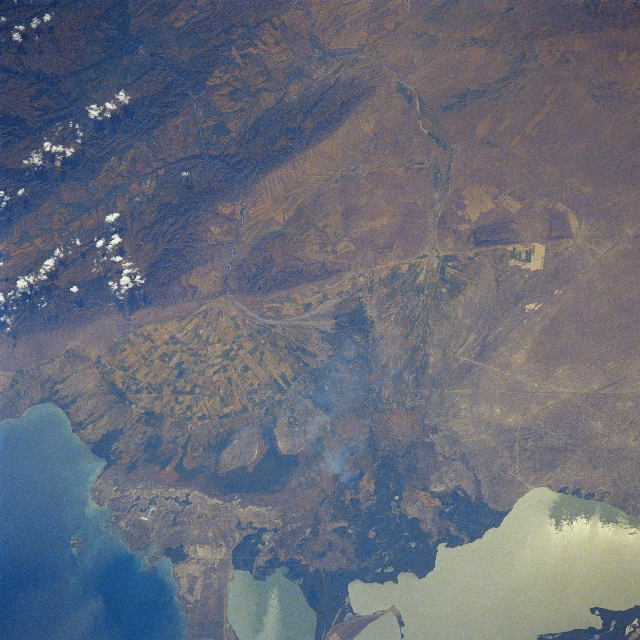 |
| STS028-091-00B Dzhungarsk Range, Sasykkol Salt Lake, Kazakhstan August 1989 The northern part of the Dzhungarsk Range can be seen in the upper left portion of the image in this southwest-looking view. The southern part of Sasykkol Salt Lake (highly reflective surface) is visible in the lower right part of the image. The northwestern part of Alakol Salt Lake is discernible in the lower left portion of the image. Roads are visible traversing the scene from just below the right corner of the image (northwest) exiting the scene at the left center of the image. These roads are the main transportation routes between China and Kazakhstan. A large alluvial fan covered with agricultural fields is visible midway between the left center and center of the image. A smoke plume is discernible in the lowland marshes of the Shinzhaly River Plain midway between the bottom center and center of the image. |
| Images: | All Available Images Low-Resolution 374k |
|
| Mission: | STS028 |
|
| Roll - Frame: | 91 - B |
|
| Geographical Name: | KAZAKHSTAN |
|
| Features: | LAKE SASYKKOL |
|
| Center Lat x Lon: | 46.0N x 81.0E |
|
| Film Exposure: | N | N=Normal exposure, U=Under exposed, O=Over exposed, F=out of Focus |
| Percentage of Cloud Cover-CLDP: | 5 |
|
| Camera:: | HB |
|
| Camera Tilt: | LO | LO=Low Oblique, HO=High Oblique, NV=Near Vertical |
| Camera Focal Length: | 250 |
|
| Nadir to Photo Center Direction: | The direction from the nadir to the center point, N=North, S=South, E=East, W=West |
|
| Stereo?: | N | Y=Yes there is an adjacent picture of the same area, N=No there isn't |
| Orbit Number: | |
|
| Date: | 198908__ | YYYYMMDD |
| Time: | GMT HHMMSS |
|
| Nadir Lat: | N |
Latitude of suborbital point of spacecraft |
| Nadir Lon: | E |
Longitude of suborbital point of spacecraft |
| Sun Azimuth: | Clockwise angle in degrees from north to the sun measured at the nadir point |
|
| Space Craft Altitude: | nautical miles |
|
| Sun Elevation: | Angle in degrees between the horizon and the sun, measured at the nadir point |
|
| Land Views: | MOUNTAIN, PLAIN, DESERT |
|
| Water Views: | LAKE |
|
| Atmosphere Views: | PLUME |
|
| Man Made Views: | AGRICULTURE |
|
| City Views: | |
|
Photo is not associated with any sequences | ||
| NASA Home Page |
JSC Home Page |
JSC Digital Image Collection |
Earth Science & Remote Sensing |
|
This service is provided by the International Space Station program and the JSC Earth Science & Remote Sensing Unit, ARES Division, Exploration Integration Science Directorate.

|