
Geographic Region: USA-MONTANA
Feature: FLATHEAD LAKE
|
Geographic Region: USA-MONTANA Feature: FLATHEAD LAKE |
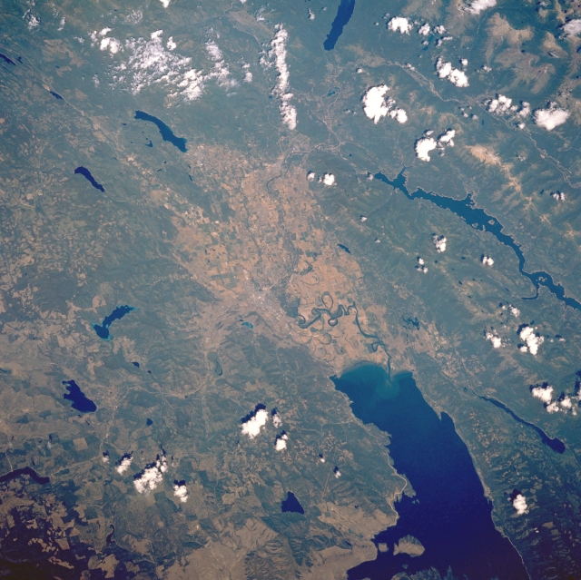 |
| STS028-090-018 Flathead Lake and Kalispell, Montana, U.S.A. August 1989 Flathead Lake and the valley to the north, part of the southern extension of the Rocky Mountain Trench, are featured in this north-northeast-looking, low-oblique photograph. Formed by glacial damming of the Flathead River during the last ice age, Flathead Lake is 30 miles (48 kilometers) long and 12 to 14 miles (19 to 23 kilometers) wide. Barely discernible is the small city of Kalispell north-northwest of the lake--a tourist center, trade center, and production center for livestock, grain, fruit, timber, and aluminum. Surrounding Kalispell are small Ashley Lake and rectangular Little Bitteroot Lake to the west; Whitefish Lake and smaller Tully Lake to the north; and long, narrow Hungry Horse Reservoir to the east, completed in 1953 and used for hydroelectric power, irrigation, navigation, and recreation. Near the top center of the photograph are Glacier National Park and Lake McDonald. |
| Images: | All Available Images Low-Resolution 364k |
|
| Mission: | STS028 |
|
| Roll - Frame: | 90 - 18 |
|
| Geographical Name: | USA-MONTANA |
|
| Features: | FLATHEAD LAKE |
|
| Center Lat x Lon: | 48.0N x 114W |
|
| Film Exposure: | N | N=Normal exposure, U=Under exposed, O=Over exposed, F=out of Focus |
| Percentage of Cloud Cover-CLDP: | 10 |
|
| Camera:: | HB |
|
| Camera Tilt: | 41 | LO=Low Oblique, HO=High Oblique, NV=Near Vertical |
| Camera Focal Length: | 250 |
|
| Nadir to Photo Center Direction: | E | The direction from the nadir to the center point, N=North, S=South, E=East, W=West |
| Stereo?: | N | Y=Yes there is an adjacent picture of the same area, N=No there isn't |
| Orbit Number: | 70 |
|
| Date: | 19890812 | YYYYMMDD |
| Time: | 210917 | GMT HHMMSS |
| Nadir Lat: | 47.0N |
Latitude of suborbital point of spacecraft |
| Nadir Lon: | 116.1W |
Longitude of suborbital point of spacecraft |
| Sun Azimuth: | 214 | Clockwise angle in degrees from north to the sun measured at the nadir point |
| Space Craft Altitude: | 162 | nautical miles |
| Sun Elevation: | 54 | Angle in degrees between the horizon and the sun, measured at the nadir point |
| Land Views: | VALLEY, FOREST |
|
| Water Views: | LAKE |
|
| Atmosphere Views: | |
|
| Man Made Views: | AGRICULTURE |
|
| City Views: | |
|
Photo is not associated with any sequences | ||
| NASA Home Page |
JSC Home Page |
JSC Digital Image Collection |
Earth Science & Remote Sensing |
|
This service is provided by the International Space Station program and the JSC Earth Science & Remote Sensing Unit, ARES Division, Exploration Integration Science Directorate.

|