Geographic Region: USA-ALASKA
Feature: MALASPINA GLACIER
|
Geographic Region: USA-ALASKA Feature: MALASPINA GLACIER |
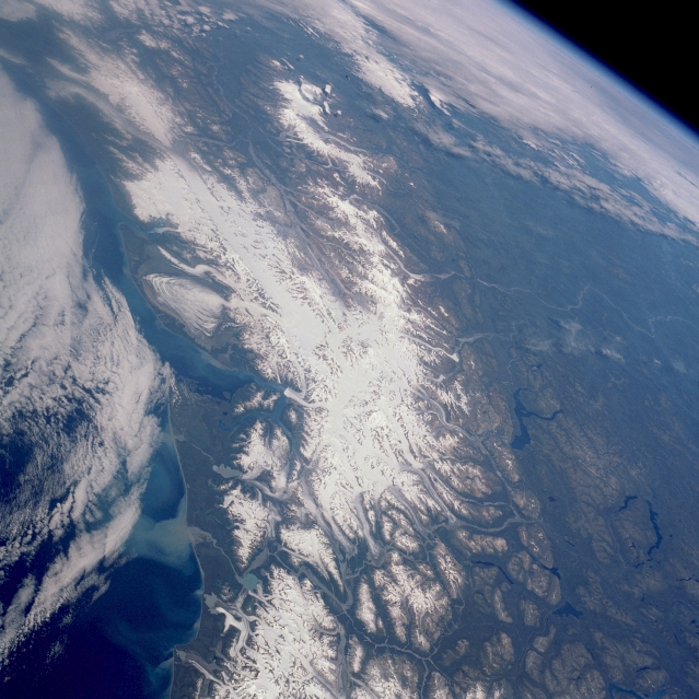 |
| STS028-089-083 Saint Elias Mountains, Yukon, Canada August 1989 The extensive white area in the center of this high-oblique, northeast-looking photograph is the snow- and ice-covered Saint Elias Mountains in the southwest Yukon Territory of Canada. Mt. Logan at 19 550 feet (5959 meters) is the highest peak in a range where most of the peaks exceed 12 000 feet (3655 meters) above sea level. Numerous glaciers radiating outward from the central section of each mountain are found in the valleys. Probably the most notable glaciers in the range are Seward Glacier and Malaspina Glacier, which is actually located in the Alaskan panhandle along the north side of Yakutat Bay. From space Malaspina is the most recognizable glacier because of its location along the Gulf of Alaska coast and its unique lobe-like shape. A classic example of a piedmont glacier, Malaspina is fed by the Seward Glacier and by many other tributary glaciers. While numerous fjords (sunken valleys) and some outwash debris (a form of sediment plume) are visible in the coastal waters, many broad U-shaped valleys appear in the northeastern mountains as the drainage flows toward the interior. Two rivers can be seen--a segment of the White River, a tributary of the Yukon River, with its multibraided channels flowing generally toward the north, and the headwaters and multibraided channels of the Chitina River flowing northwest and emptying eventually into the Copper River in Alaska. An extensive area of cloudiness off the Alaskan coast obscures the coastal waters of the Gulf of Alaska. |
| Images: | All Available Images Low-Resolution 337k |
|
| Mission: | STS028 |
|
| Roll - Frame: | 89 - 83 |
|
| Geographical Name: | USA-ALASKA |
|
| Features: | MALASPINA GLACIER |
|
| Center Lat x Lon: | 61.0N x 141W |
|
| Film Exposure: | N | N=Normal exposure, U=Under exposed, O=Over exposed, F=out of Focus |
| Percentage of Cloud Cover-CLDP: | 30 |
|
| Camera:: | HB |
|
| Camera Tilt: | HO | LO=Low Oblique, HO=High Oblique, NV=Near Vertical |
| Camera Focal Length: | 100 |
|
| Nadir to Photo Center Direction: | NW | The direction from the nadir to the center point, N=North, S=South, E=East, W=West |
| Stereo?: | N | Y=Yes there is an adjacent picture of the same area, N=No there isn't |
| Orbit Number: | 37 |
|
| Date: | 19890810 | YYYYMMDD |
| Time: | 191249 | GMT HHMMSS |
| Nadir Lat: | 56.3N |
Latitude of suborbital point of spacecraft |
| Nadir Lon: | 136W |
Longitude of suborbital point of spacecraft |
| Sun Azimuth: | 140 | Clockwise angle in degrees from north to the sun measured at the nadir point |
| Space Craft Altitude: | 161 | nautical miles |
| Sun Elevation: | 44 | Angle in degrees between the horizon and the sun, measured at the nadir point |
| Land Views: | MOUNTAIN, GLACIER, VALLEY, COAST |
|
| Water Views: | BAY, INLET, OCEAN, RIVER, LAKE, SEDIMENT |
|
| Atmosphere Views: | |
|
| Man Made Views: | |
|
| City Views: | |
|
Photo is not associated with any sequences | ||
| NASA Home Page |
JSC Home Page |
JSC Digital Image Collection |
Earth Science & Remote Sensing |
|
This service is provided by the International Space Station program and the JSC Earth Science & Remote Sensing Unit, ARES Division, Exploration Integration Science Directorate.

|