
Geographic Region: KAZAKHSTAN
Feature: CASPIAN SEA
|
Geographic Region: KAZAKHSTAN Feature: CASPIAN SEA |
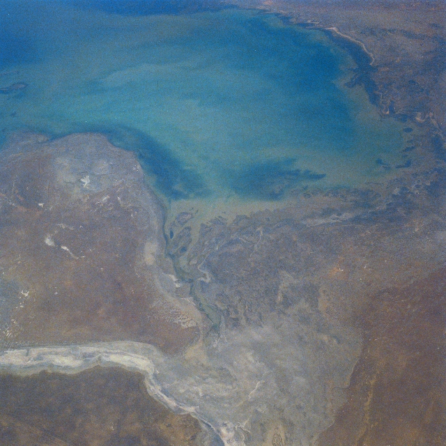 |
| STS028-087-061 Caspian Sea, Mertvyy Kultuk Salt Flat, Kazakhstan August 1989 This west-looking view shows the northeast section of the Caspian Sea. The Caspian Sea is the world's largest inland expanse of water. The northern part of the sea visible in this view, reaches a depth of only 17 feet (5 meters). The Mertvyy Kultuk Salt Flat (bottom center) and the Kaydak Salt Flat (bottom left) are a part of the Caspian Depression and were once covered with water. The mouth of the Ural River is visible along the top of the image. The outer edges of the Volga River Delta are visible near the top center of the image. The area shown in this view is semi-arid, and is also noted for its many oil and gas fields. |
| Images: | All Available Images Low-Resolution 352k |
|
| Mission: | STS028 |
|
| Roll - Frame: | 87 - 61 |
|
| Geographical Name: | KAZAKHSTAN |
|
| Features: | CASPIAN SEA |
|
| Center Lat x Lon: | 45.5N x 53.0E |
|
| Film Exposure: | N | N=Normal exposure, U=Under exposed, O=Over exposed, F=out of Focus |
| Percentage of Cloud Cover-CLDP: | 0 |
|
| Camera:: | HB |
|
| Camera Tilt: | 53 | LO=Low Oblique, HO=High Oblique, NV=Near Vertical |
| Camera Focal Length: | 100 |
|
| Nadir to Photo Center Direction: | W | The direction from the nadir to the center point, N=North, S=South, E=East, W=West |
| Stereo?: | N | Y=Yes there is an adjacent picture of the same area, N=No there isn't |
| Orbit Number: | 47 |
|
| Date: | 19890811 | YYYYMMDD |
| Time: | 102824 | GMT HHMMSS |
| Nadir Lat: | 44.6N |
Latitude of suborbital point of spacecraft |
| Nadir Lon: | 56.5E |
Longitude of suborbital point of spacecraft |
| Sun Azimuth: | 233 | Clockwise angle in degrees from north to the sun measured at the nadir point |
| Space Craft Altitude: | 163 | nautical miles |
| Sun Elevation: | 50 | Angle in degrees between the horizon and the sun, measured at the nadir point |
| Land Views: | DESERT |
|
| Water Views: | SEA, RIVER, PLAYA |
|
| Atmosphere Views: | |
|
| Man Made Views: | |
|
| City Views: | |
|
Photo is not associated with any sequences | ||
| NASA Home Page |
JSC Home Page |
JSC Digital Image Collection |
Earth Science & Remote Sensing |
|
This service is provided by the International Space Station program and the JSC Earth Science & Remote Sensing Unit, ARES Division, Exploration Integration Science Directorate.

|