Geographic Region: USA-ALASKA
Feature: BARANOF ISLAND
|
Geographic Region: USA-ALASKA Feature: BARANOF ISLAND |
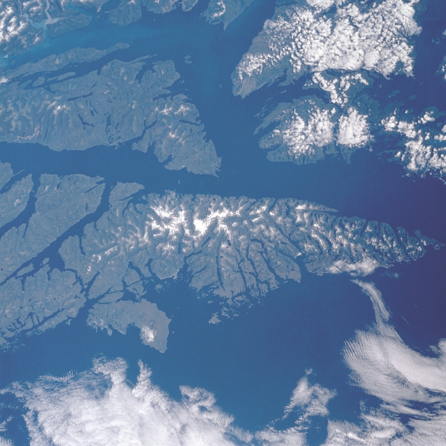 |
| STS028-083-057 Baranof Island and Chatham Strait, Alaska, U.S.A. August 1989 Parts of several heavily forested islands that constitute the Alaskan panhandle are visible in this photograph. Snowcapped peaks and ridge lines appear in some of the higher elevations of southward-pointing Baranof Island. Kuiu Island and Kupreanof Island are covered by clouds. Frederick Sound extends eastward from north-south-oriented Chatham Strait, which borders the eastern shore of Baranof Island. Both the sound and the strait are part of the Inside Passage, a sheltered waterway that operates from Seattle, Washington, to Skagway, Alaska. A section of Stephens Passage, an alternate route of the Inside Passage, is visible along the eastern coast of Admiralty Island. |
| Images: | All Available Images Low-Resolution 330k |
|
| Mission: | STS028 |
|
| Roll - Frame: | 83 - 57 |
|
| Geographical Name: | USA-ALASKA |
|
| Features: | BARANOF ISLAND |
|
| Center Lat x Lon: | 57.0N x 135W |
|
| Film Exposure: | N | N=Normal exposure, U=Under exposed, O=Over exposed, F=out of Focus |
| Percentage of Cloud Cover-CLDP: | 20 |
|
| Camera:: | HB |
|
| Camera Tilt: | 24 | LO=Low Oblique, HO=High Oblique, NV=Near Vertical |
| Camera Focal Length: | 100 |
|
| Nadir to Photo Center Direction: | N | The direction from the nadir to the center point, N=North, S=South, E=East, W=West |
| Stereo?: | N | Y=Yes there is an adjacent picture of the same area, N=No there isn't |
| Orbit Number: | 54 |
|
| Date: | 19890811 | YYYYMMDD |
| Time: | 205609 | GMT HHMMSS |
| Nadir Lat: | 55.9N |
Latitude of suborbital point of spacecraft |
| Nadir Lon: | 135.5W |
Longitude of suborbital point of spacecraft |
| Sun Azimuth: | 176 | Clockwise angle in degrees from north to the sun measured at the nadir point |
| Space Craft Altitude: | 162 | nautical miles |
| Sun Elevation: | 49 | Angle in degrees between the horizon and the sun, measured at the nadir point |
| Land Views: | ISLAND |
|
| Water Views: | STRAIT |
|
| Atmosphere Views: | |
|
| Man Made Views: | |
|
| City Views: | |
|
Photo is not associated with any sequences | ||
| NASA Home Page |
JSC Home Page |
JSC Digital Image Collection |
Earth Science & Remote Sensing |
|
This service is provided by the International Space Station program and the JSC Earth Science & Remote Sensing Unit, ARES Division, Exploration Integration Science Directorate.

|