Geographic Region: CANADA-A
Feature: PEACE RIVER
|
Geographic Region: CANADA-A Feature: PEACE RIVER |
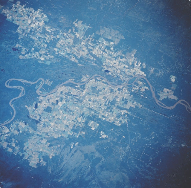 |
| STS028-082-048 Fort Vermilion Area, Alberta, Canada August 1989 The meandering course of the northeasterly flowing Peace River is visible, as the river separates two agricultural areas in north central Alberta. The small, remote town of Fort Vermilion (not discernible on this image) is located slightly right of center on the south side of the Peace River. The landscape immediately north of the river is drained by a number of smaller tributary streams that enter the Peace River in the vicinity of Fort Vermilion. Large, cultivated field patterns (variety of lighter colors) dominate the landscape on both sides of the river where the terrain is fairly flat and has adequate drainage. The lighter shaded area within the forested northwest corner of the Buffalo Head Hills (bottom center) might be fire scars. |
| Images: | All Available Images Low-Resolution 348k |
|
| Mission: | STS028 |
|
| Roll - Frame: | 82 - 48 |
|
| Geographical Name: | CANADA-A |
|
| Features: | PEACE RIVER |
|
| Center Lat x Lon: | 58.5N x 116W |
|
| Film Exposure: | N | N=Normal exposure, U=Under exposed, O=Over exposed, F=out of Focus |
| Percentage of Cloud Cover-CLDP: | 5 |
|
| Camera:: | HB |
|
| Camera Tilt: | NV | LO=Low Oblique, HO=High Oblique, NV=Near Vertical |
| Camera Focal Length: | 250 |
|
| Nadir to Photo Center Direction: | NW | The direction from the nadir to the center point, N=North, S=South, E=East, W=West |
| Stereo?: | N | Y=Yes there is an adjacent picture of the same area, N=No there isn't |
| Orbit Number: | 21 |
|
| Date: | 19890809 | YYYYMMDD |
| Time: | 190612 | GMT HHMMSS |
| Nadir Lat: | 57.2N |
Latitude of suborbital point of spacecraft |
| Nadir Lon: | 115W |
Longitude of suborbital point of spacecraft |
| Sun Azimuth: | 166 | Clockwise angle in degrees from north to the sun measured at the nadir point |
| Space Craft Altitude: | 162 | nautical miles |
| Sun Elevation: | 48 | Angle in degrees between the horizon and the sun, measured at the nadir point |
| Land Views: | FOREST, HILL |
|
| Water Views: | RIVER |
|
| Atmosphere Views: | |
|
| Man Made Views: | |
|
| City Views: | |
|
Photo is not associated with any sequences | ||
| NASA Home Page |
JSC Home Page |
JSC Digital Image Collection |
Earth Science & Remote Sensing |
|
This service is provided by the International Space Station program and the JSC Earth Science & Remote Sensing Unit, ARES Division, Exploration Integration Science Directorate.

|