Geographic Region: USA-ALASKA
Feature: BARANOF ISLAND
|
Geographic Region: USA-ALASKA Feature: BARANOF ISLAND |
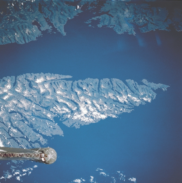 |
| STS028-082-040 Southern Baranof Island, Alaska, U.S.A. August 1989 Heavily forested southern Baranof Island is visible lying between the Pacific Ocean to the west and Chatham Strait to the east. Also discernible are scattered clouds overhanging snowcapped peaks; Whale Bay, the larger inlet along the west coast; and the tip of the Space Shuttle tail near the bottom left of the photograph. |
| Images: | All Available Images Low-Resolution 305k |
|
| Mission: | STS028 |
|
| Roll - Frame: | 82 - 40 |
|
| Geographical Name: | USA-ALASKA |
|
| Features: | BARANOF ISLAND |
|
| Center Lat x Lon: | 56.5N x 135W |
|
| Film Exposure: | N | N=Normal exposure, U=Under exposed, O=Over exposed, F=out of Focus |
| Percentage of Cloud Cover-CLDP: | 5 |
|
| Camera:: | HB |
|
| Camera Tilt: | LO | LO=Low Oblique, HO=High Oblique, NV=Near Vertical |
| Camera Focal Length: | 250 |
|
| Nadir to Photo Center Direction: | The direction from the nadir to the center point, N=North, S=South, E=East, W=West |
|
| Stereo?: | N | Y=Yes there is an adjacent picture of the same area, N=No there isn't |
| Orbit Number: | |
|
| Date: | 198908__ | YYYYMMDD |
| Time: | GMT HHMMSS |
|
| Nadir Lat: | N |
Latitude of suborbital point of spacecraft |
| Nadir Lon: | E |
Longitude of suborbital point of spacecraft |
| Sun Azimuth: | Clockwise angle in degrees from north to the sun measured at the nadir point |
|
| Space Craft Altitude: | nautical miles |
|
| Sun Elevation: | Angle in degrees between the horizon and the sun, measured at the nadir point |
|
| Land Views: | ISLAND |
|
| Water Views: | STRAIT |
|
| Atmosphere Views: | |
|
| Man Made Views: | |
|
| City Views: | |
|
Photo is not associated with any sequences | ||
| NASA Home Page |
JSC Home Page |
JSC Digital Image Collection |
Earth Science & Remote Sensing |
|
This service is provided by the International Space Station program and the JSC Earth Science & Remote Sensing Unit, ARES Division, Exploration Integration Science Directorate.

|