Geographic Region: CANADA-A
Feature: ATHABASCA RIVER
|
Geographic Region: CANADA-A Feature: ATHABASCA RIVER |
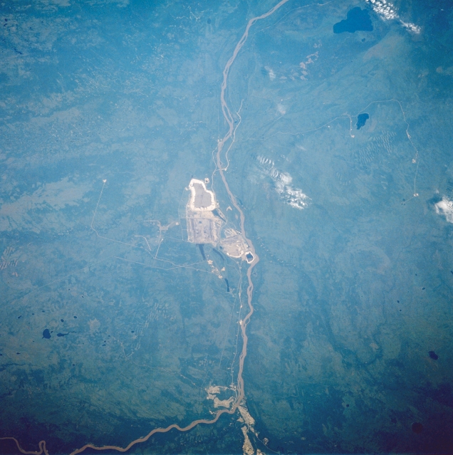 |
| STS028-082-032 Athabasca River, Alberta, Canada August 1989 The Athabasca River is visible as it flows northward across the boreal plain in northeast Alberta. The feature in the center of the image and along the western side of the Athabasca River is man made and is associated with the development of Athabasca oil sands. The location of Fort McMurray is identifiable near the bottom of the picture where the river makes a 90 degree turn (course change). The large dark feature near the top and east of the river is McClelland Lake and the smaller lake south of McClelland is Kearl Lake. Drainage patterns for several tributary streams can be identified in spite of dense vegetation in the undeveloped landscape. |
| Images: | All Available Images Low-Resolution 317k |
|
| Mission: | STS028 |
|
| Roll - Frame: | 82 - 32 |
|
| Geographical Name: | CANADA-A |
|
| Features: | ATHABASCA RIVER |
|
| Center Lat x Lon: | 57.0N x 111.5W |
|
| Film Exposure: | N | N=Normal exposure, U=Under exposed, O=Over exposed, F=out of Focus |
| Percentage of Cloud Cover-CLDP: | 5 |
|
| Camera:: | HB |
|
| Camera Tilt: | NV | LO=Low Oblique, HO=High Oblique, NV=Near Vertical |
| Camera Focal Length: | 250 |
|
| Nadir to Photo Center Direction: | N | The direction from the nadir to the center point, N=North, S=South, E=East, W=West |
| Stereo?: | N | Y=Yes there is an adjacent picture of the same area, N=No there isn't |
| Orbit Number: | 20 |
|
| Date: | 19890809 | YYYYMMDD |
| Time: | 173250 | GMT HHMMSS |
| Nadir Lat: | 55.4N |
Latitude of suborbital point of spacecraft |
| Nadir Lon: | 111.4W |
Longitude of suborbital point of spacecraft |
| Sun Azimuth: | 138 | Clockwise angle in degrees from north to the sun measured at the nadir point |
| Space Craft Altitude: | 161 | nautical miles |
| Sun Elevation: | 44 | Angle in degrees between the horizon and the sun, measured at the nadir point |
| Land Views: | PLAIN |
|
| Water Views: | RIVER, LAKE |
|
| Atmosphere Views: | |
|
| Man Made Views: | MINING |
|
| City Views: | |
|
Photo is not associated with any sequences | ||
| NASA Home Page |
JSC Home Page |
JSC Digital Image Collection |
Earth Science & Remote Sensing |
|
This service is provided by the International Space Station program and the JSC Earth Science & Remote Sensing Unit, ARES Division, Exploration Integration Science Directorate.

|