
Geographic Region: FRANCE
Feature: MARSEILLE
|
Geographic Region: FRANCE Feature: MARSEILLE |
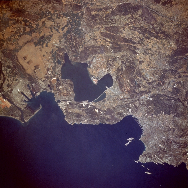 |
| STS028-078-064 Marseille, France August 1989 The blue waters of the Gulf of Lions, an arm of the Mediterranean Sea, and Lake Berre provide a marked contrast to the south-central coastal area that includes Marseille (southeastern edge of photograph), the third largest city in France; only Paris and Lyon have larger populations. The numerous hills and low mountains encircling the city restrict horizontal growth and make connections with the hinterland difficult. Both rail and canal connections between the port of Marseille and the Rhone River (western edge of photograph) go through tunnels; part of the canal system is visible in the photograph. Marseille, the oldest town in France (first settled by the Phocaean Greeks of Asia Minor about 600 B.C.), is a well-established seaport and industrial city. Most of the city's infrastructure is not discernible on this scale; however, some port facilities along its western edge and a small part of the Marseille-Marignane Airport runway jutting into the southeast side of Lake Berre are visible. |
| Images: | All Available Images Low-Resolution 360k |
|
| Mission: | STS028 |
|
| Roll - Frame: | 78 - 64 |
|
| Geographical Name: | FRANCE |
|
| Features: | MARSEILLE |
|
| Center Lat x Lon: | 43.5N x 5.0E |
|
| Film Exposure: | N | N=Normal exposure, U=Under exposed, O=Over exposed, F=out of Focus |
| Percentage of Cloud Cover-CLDP: | 0 |
|
| Camera:: | HB |
|
| Camera Tilt: | 4 | LO=Low Oblique, HO=High Oblique, NV=Near Vertical |
| Camera Focal Length: | 250 |
|
| Nadir to Photo Center Direction: | N | The direction from the nadir to the center point, N=North, S=South, E=East, W=West |
| Stereo?: | Y | Y=Yes there is an adjacent picture of the same area, N=No there isn't |
| Orbit Number: | 18 |
|
| Date: | 19890809 | YYYYMMDD |
| Time: | 144338 | GMT HHMMSS |
| Nadir Lat: | 43.3N |
Latitude of suborbital point of spacecraft |
| Nadir Lon: | 5.0E |
Longitude of suborbital point of spacecraft |
| Sun Azimuth: | 248 | Clockwise angle in degrees from north to the sun measured at the nadir point |
| Space Craft Altitude: | 166 | nautical miles |
| Sun Elevation: | 43 | Angle in degrees between the horizon and the sun, measured at the nadir point |
| Land Views: | COAST, MOUNTAIN |
|
| Water Views: | BAY, CHANNEL, RIVER, SEA |
|
| Atmosphere Views: | |
|
| Man Made Views: | URBAN AREA, AIRPORT, AGRICULTURE |
|
| City Views: | |
|
Photo is not associated with any sequences | ||
| NASA Home Page |
JSC Home Page |
JSC Digital Image Collection |
Earth Science & Remote Sensing |
|
This service is provided by the International Space Station program and the JSC Earth Science & Remote Sensing Unit, ARES Division, Exploration Integration Science Directorate.

|