
Geographic Region: USA-DC
Feature: WASHINGTON D. C.
|
Geographic Region: USA-DC Feature: WASHINGTON D. C. |
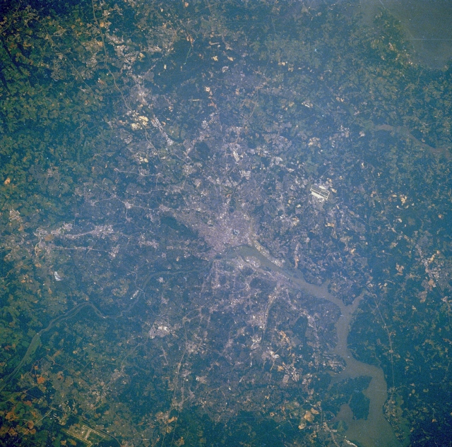 |
| STS028-078-003 Washington, District of Columbia, U.S.A. August 1989 The legislative, administrative, and judicial center of the United States, Washington, DC, can be seen in this east-northeast-looking, low-oblique photograph. Situated on the banks of the Potomac and Anacostia Rivers, the District of Columbia covers 69 square miles (179 square kilometers). The population of metropolitan Washington, which includes suburbs in both Maryland and Virginia, is the eighth largest in the United States (3.9 million). The population of the District of Columbia has decreased drastically since the mid-1960s as the population moved outward into the suburbs. The Federal Government and tourism are the major sources of employment in the city. Numerous military bases are scattered throughout the metropolitan area. Major transportation routes and bridges that cross the Potomac and Anacostia Rivers can be seen in the photograph. Visible airfields are Andrews Air Force Base east of the city and Dulles International Airport west of the city in the lower left portion of the image. The Potomac River crosses a series of small escarpments northwest of Washington, particularly at Great Falls, Maryland. As the river enters the Washington area from the northwest, it broadens, becomes a tidal estuary, and continues to flow southeastward to Chesapeake Bay. |
| Images: | All Available Images Low-Resolution 397k |
|
| Mission: | STS028 |
|
| Roll - Frame: | 78 - 3 |
|
| Geographical Name: | USA-DC |
|
| Features: | WASHINGTON D. C. |
|
| Center Lat x Lon: | 39.0N x 77W |
|
| Film Exposure: | N | N=Normal exposure, U=Under exposed, O=Over exposed, F=out of Focus |
| Percentage of Cloud Cover-CLDP: | 0 |
|
| Camera:: | HB |
|
| Camera Tilt: | 24 | LO=Low Oblique, HO=High Oblique, NV=Near Vertical |
| Camera Focal Length: | 250 |
|
| Nadir to Photo Center Direction: | E | The direction from the nadir to the center point, N=North, S=South, E=East, W=West |
| Stereo?: | Y | Y=Yes there is an adjacent picture of the same area, N=No there isn't |
| Orbit Number: | 17 |
|
| Date: | 19890809 | YYYYMMDD |
| Time: | 125336 | GMT HHMMSS |
| Nadir Lat: | 39.0N |
Latitude of suborbital point of spacecraft |
| Nadir Lon: | 78.2W |
Longitude of suborbital point of spacecraft |
| Sun Azimuth: | 92 | Clockwise angle in degrees from north to the sun measured at the nadir point |
| Space Craft Altitude: | 161 | nautical miles |
| Sun Elevation: | 28 | Angle in degrees between the horizon and the sun, measured at the nadir point |
| Land Views: | PLAIN, HILL, FOREST |
|
| Water Views: | RIVER, ESTUARY |
|
| Atmosphere Views: | |
|
| Man Made Views: | URBAN AREA, AIRPORT, AGRICULTURE |
|
| City Views: | |
|
Photo is not associated with any sequences | ||
| NASA Home Page |
JSC Home Page |
JSC Digital Image Collection |
Earth Science & Remote Sensing |
|
This service is provided by the International Space Station program and the JSC Earth Science & Remote Sensing Unit, ARES Division, Exploration Integration Science Directorate.

|