
Geographic Region: USA-SOUTH DAKOTA
Feature: MISSOURI R., LAKE SHARPE
|
Geographic Region: USA-SOUTH DAKOTA Feature: MISSOURI R., LAKE SHARPE |
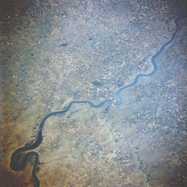 |
| STS028-076-058 Lake Francis Case, South Dakota, U.S.A. August 1989 Lake Francis Case, 150 miles (242 kilometers) long, is visible in this east-looking, low-oblique photograph. Fort Randall Dam (not visible) that impounds the waters of Lake Francis Case was completed in 1952. The dam and lake provide hydroelectric power, water for irrigation, flood control, and recreation. The White River enters Lake Francis Case with white silt brought downstream from the badlands farther west. Visible to the north is the big bend of the Missouri River near which are center-pivot irrigation fields. |
| Images: | All Available Images Low-Resolution 381k |
|
| Mission: | STS028 |
|
| Roll - Frame: | 76 - 58 |
|
| Geographical Name: | USA-SOUTH DAKOTA |
|
| Features: | MISSOURI R., LAKE SHARPE |
|
| Center Lat x Lon: | 43.5N x 99.5W |
|
| Film Exposure: | N | N=Normal exposure, U=Under exposed, O=Over exposed, F=out of Focus |
| Percentage of Cloud Cover-CLDP: | 0 |
|
| Camera:: | HB |
|
| Camera Tilt: | 53 | LO=Low Oblique, HO=High Oblique, NV=Near Vertical |
| Camera Focal Length: | 250 |
|
| Nadir to Photo Center Direction: | E | The direction from the nadir to the center point, N=North, S=South, E=East, W=West |
| Stereo?: | N | Y=Yes there is an adjacent picture of the same area, N=No there isn't |
| Orbit Number: | 7 |
|
| Date: | 19890808 | YYYYMMDD |
| Time: | 220734 | GMT HHMMSS |
| Nadir Lat: | 43.9N |
Latitude of suborbital point of spacecraft |
| Nadir Lon: | 103.1W |
Longitude of suborbital point of spacecraft |
| Sun Azimuth: | 250 | Clockwise angle in degrees from north to the sun measured at the nadir point |
| Space Craft Altitude: | 163 | nautical miles |
| Sun Elevation: | 41 | Angle in degrees between the horizon and the sun, measured at the nadir point |
| Land Views: | PLAIN |
|
| Water Views: | RIVER, LAKE |
|
| Atmosphere Views: | |
|
| Man Made Views: | AGRICULTURE, DAM, PIVOT IRRIGATION |
|
| City Views: | |
|
Photo is not associated with any sequences | ||
| NASA Home Page |
JSC Home Page |
JSC Digital Image Collection |
Earth Science & Remote Sensing |
|
This service is provided by the International Space Station program and the JSC Earth Science & Remote Sensing Unit, ARES Division, Exploration Integration Science Directorate.

|