
Geographic Region: USA-SOUTH DAKOTA
Feature: MISSOURI RIVER,LAKE OAHE
|
Geographic Region: USA-SOUTH DAKOTA Feature: MISSOURI RIVER,LAKE OAHE |
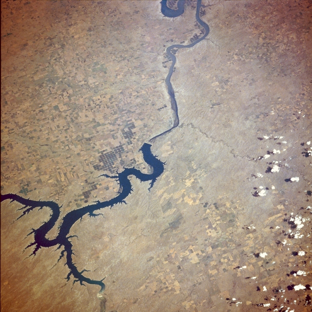 |
| STS028-076-056 Oahe Reservoir and Missouri River, South Dakota, U.S.A. August 1989 The Oahe Reservoir in this southeast-looking, low-oblique photograph is one of many dams and reservoirs constructed in the late 1940s and the 1950s along the Missouri River, from eastern Montana through North Dakota and South Dakota. These reservoirs were built to provide flood control, hydroelectric power, irrigation, and recreation. Dams like the Oahe serve to impound, for later use, water from spring rains and snowmelt that swells the volume of the Missouri River during early and mid-spring. The dams also protect the countryside from a second flood stage that frequently occurs in June as the snow melts in the remote mountain systems to the west. As of 1984, the Oahe Dam was the largest rolled-earth dam in the United States. Problems continue to occur with the construction of these dams and large reservoirs. They cause large areas of once valuable farmland to be flooded permanently, resulting in losses in millions of dollars in farm revenue yearly. In addition, silt, fertilizers, and pesticides in the runoff from agricultural lands pollute the waters of these reservoirs. The positive and negative debates regarding the usefulness of these reservoirs continue today. Pierre, the capital of South Dakota, is barely discernible near the center of the photograph just southeast of the Oahe Dam, where the Bad River from the southwest joins the Missouri River. |
| Images: | All Available Images Low-Resolution 368k |
|
| Mission: | STS028 |
|
| Roll - Frame: | 76 - 56 |
|
| Geographical Name: | USA-SOUTH DAKOTA |
|
| Features: | MISSOURI RIVER,LAKE OAHE |
|
| Center Lat x Lon: | 44.5N x 100.5W |
|
| Film Exposure: | N | N=Normal exposure, U=Under exposed, O=Over exposed, F=out of Focus |
| Percentage of Cloud Cover-CLDP: | 5 |
|
| Camera:: | HB |
|
| Camera Tilt: | LO | LO=Low Oblique, HO=High Oblique, NV=Near Vertical |
| Camera Focal Length: | 250 |
|
| Nadir to Photo Center Direction: | E | The direction from the nadir to the center point, N=North, S=South, E=East, W=West |
| Stereo?: | N | Y=Yes there is an adjacent picture of the same area, N=No there isn't |
| Orbit Number: | 7 |
|
| Date: | 19890808 | YYYYMMDD |
| Time: | 220714 | GMT HHMMSS |
| Nadir Lat: | 44.8N |
Latitude of suborbital point of spacecraft |
| Nadir Lon: | 104.4W |
Longitude of suborbital point of spacecraft |
| Sun Azimuth: | 248 | Clockwise angle in degrees from north to the sun measured at the nadir point |
| Space Craft Altitude: | 163 | nautical miles |
| Sun Elevation: | 42 | Angle in degrees between the horizon and the sun, measured at the nadir point |
| Land Views: | PLAIN |
|
| Water Views: | RIVER, RESERVOIR |
|
| Atmosphere Views: | |
|
| Man Made Views: | URBAN AREA, AGRICULTURE, PIVOT IRRIGATION |
|
| City Views: | |
|
Photo is not associated with any sequences | ||
| NASA Home Page |
JSC Home Page |
JSC Digital Image Collection |
Earth Science & Remote Sensing |
|
This service is provided by the International Space Station program and the JSC Earth Science & Remote Sensing Unit, ARES Division, Exploration Integration Science Directorate.

|