
Geographic Region: USA-MONTANA
Feature: MISSOURI RIVER
|
Geographic Region: USA-MONTANA Feature: MISSOURI RIVER |
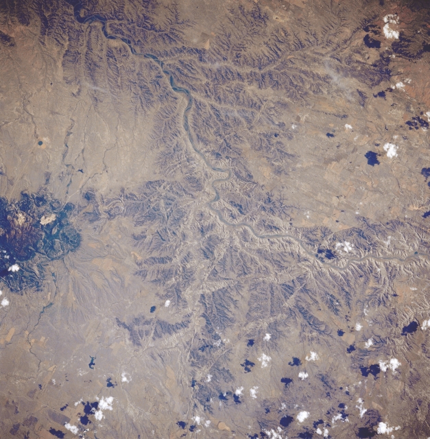 |
| STS028-076-054 Missouri River and Little Rocky Mountains, Montana, U.S.A. August 1989 The Missouri River, heavy with silt and bounded in many places by steep cliffs; portions of the Little Rocky Mountains, an isolated cluster of low igneous rock peaks that were uplifted through the rocks of the high Great Plains 50 million years ago; and numerous canyonlike features are visible in this southeast-looking, low-oblique photograph. This region of the river is part of the Missouri Breaks Wild and Scenic River Area. Just below the top of the photograph, Armells Creek can be seen as it enters the Missouri River. |
| Images: | All Available Images Low-Resolution 370k |
|
| Mission: | STS028 |
|
| Roll - Frame: | 76 - 54 |
|
| Geographical Name: | USA-MONTANA |
|
| Features: | MISSOURI RIVER |
|
| Center Lat x Lon: | 48.0N x 109W |
|
| Film Exposure: | N | N=Normal exposure, U=Under exposed, O=Over exposed, F=out of Focus |
| Percentage of Cloud Cover-CLDP: | 10 |
|
| Camera:: | HB |
|
| Camera Tilt: | 28 | LO=Low Oblique, HO=High Oblique, NV=Near Vertical |
| Camera Focal Length: | 250 |
|
| Nadir to Photo Center Direction: | E | The direction from the nadir to the center point, N=North, S=South, E=East, W=West |
| Stereo?: | N | Y=Yes there is an adjacent picture of the same area, N=No there isn't |
| Orbit Number: | 7 |
|
| Date: | 19890808 | YYYYMMDD |
| Time: | 220551 | GMT HHMMSS |
| Nadir Lat: | 48.2N |
Latitude of suborbital point of spacecraft |
| Nadir Lon: | 110.4W |
Longitude of suborbital point of spacecraft |
| Sun Azimuth: | 239 | Clockwise angle in degrees from north to the sun measured at the nadir point |
| Space Craft Altitude: | 163 | nautical miles |
| Sun Elevation: | 44 | Angle in degrees between the horizon and the sun, measured at the nadir point |
| Land Views: | HILL |
|
| Water Views: | RIVER |
|
| Atmosphere Views: | |
|
| Man Made Views: | |
|
| City Views: | |
|
Photo is not associated with any sequences | ||
| NASA Home Page |
JSC Home Page |
JSC Digital Image Collection |
Earth Science & Remote Sensing |
|
This service is provided by the International Space Station program and the JSC Earth Science & Remote Sensing Unit, ARES Division, Exploration Integration Science Directorate.

|